Showing posts with label Sculls Shoals. Show all posts

Thursday, December 2, 2010

Field Trip: Scull Shoals. Part 4, Town Ruins – Oconee River Bridge & Superintendent’s House

We walked from the power plant west to the Oconee River to look at the remains of the bridge that had once crossed it, and then back over to the remains of the superintendent’s house.

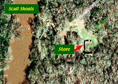
The arched bridge and power plant are located to the south and slightly west of the store.

A sign indicates that the trail from the Oconee River Recreation Area parking lot is closed.

The Oconee River, looking to the north. The remains of the bridge are in the foreground – on the shore and on the ‘island’ in the river.

The shore line on the east side of the river. This section is rock and is a solid base for the bridge. The west side of the river doesn’t have this rock base and nothing remains of the bridge on that side.

The remains of the bridge pier on the island. Stone blocks are clearly visible.

A closer view of one of the stones. This shows the drilled holes that were used to guide the splitting of the stone. After the holes were drilled, dry wood dowels were hammered into them and moistened. The dowels expanded and caused the rock to split along the line of holes. At least two such stones were visible from the shore.

An iron rod was placed in a hole drilled in the rock on the shore at the approach to the bridge. Another hole remains on the other side of the approach but the rod has been removed at some time.

We climbed back up the bank and walked towards the parking lot. This took us directly past the superintendent’s house.


Looking from the ‘store side’ only a mound with some stones are visible.

From the’ river side’, a chamber lined with blue stone remains in relatively good repair. This is believed to have been a cellar.

A closer view of the cellar walls.

In addition to this site, there is a trail to the remains of the manager’s house. We didn’t have time to walk over to it; that will have to wait for another trip.

Click on an image to view a larger image


Resources:

- Trip map (Google): Scull Shoals

- Friends of Scull Shoals: A Brief History of Scull Shoals Mill Village


Related posts:

- Field Trip: Scull Shoals. Part 1, Oconee River – Sandy Creek

- Field Trip: Scull Shoals. Part 2, Town Ruins – Store

- Field Trip: Scull Shoals. Part 3, Town Ruins – Arched Bridge & Power Plant

- Field Trip: Oconee-Greene County. Part 1, Elders Mill Covered Bridge

- Field Trip: Oconee-Greene County. Part 2, Sand Pit – Ward Rd

- Field Trip: Oconee-Greene County. Part 3. Oconee National Forest & Fishing Creek

Tuesday, November 30, 2010

Field Trip: Scull Shoals. Part 3, Town Ruins – Arched Bridge & Power Plant

From the store, we made our way towards the area where the arched bridge over the raceway and the power plant were located.

The arched bridge and power plant are located to the south and slightly west of the store.

On our way, we stumbled over this beautiful colony of bracket fungi.

The area where the arched bridge and power plant were located was somewhat overgrown and it would have been easy to give up the search. We got a glimpse of stonework supports and decided to try to get through to get a better look.

We rounded a chain-link fence and were rewarded with a glimpse of the arched bridge. Certainly worth a closer look. It’s a pity that the bridge is enclosed by a fence but this is probably necessary to preserve it since it is vulnerable.

A view of the bridge. We have dropped down into a ditch which was the raceway to bring water from the Oconee River to the power plant. We walked carefully in the leaves. It was still warm enough for snakes to be about and Timber/Canebreak Rattlesnakes (Crotalus horridus) could 'hide' in plain sight in these leaves.

A closer view of the brickwork on the arch of the bridge.

We climbed up out of the raceway and were treated to an overview of the power plant foundations. A wall to the right and supports for the floor.

A closer view of the wall to the right of the previous photo.

Looking straight at the wall on the right. This view shows the excellent stone masonry.

*****
A closer view of a couple of the center supports.

This arched structure is partially buried in the ground. I don’t know what it is but it's another excellent example of decorative stonework.

From here we set off to the Oconee River to look at the foundations for the bridge that crossed the river and then back up to the ledge to the remains of the superintendent’s house.

Click on an image to view a larger image

Resources:
Trip map (Google): Scull Shoals

Friends of Scull Shoals: A Brief History of Scull Shoals Mill Village


Related posts:

- Field Trip: Scull Shoals. Part 1, Oconee River – Sandy Creek

- Field Trip: Scull Shoals. Part 2, Town Ruins – Store

- Field Trip: Oconee-Greene County. Part 1, Elders Mill Covered Bridge

- Field Trip: Oconee-Greene County. Part 2, Sand Pit – Ward Rd

- Field Trip: Oconee-Greene County. Part 3. Oconee National Forest & Fishing Creek

Sunday, November 28, 2010

Field Trip: Scull Shoals. Part 2, Town Ruins - Store

The Scull Shoals site is at the end of Scull Shoals Road. A Visitor Information display has a poster with a diagram of the town and a brief history which are very informative. It’s helpful to understand the layout of the town before starting to explore.

The site is visible on Google maps. (The parking area is in the upper right of the map).

The buildings at Sculls Shoals are in ruins. Anything made of wood is gone. Foundations and the store - the only structures made of stone or brick – are all that remain. Since the town is in ruins and very little stands above ground, we found ourselves using the photograph we took of the diagram on the visitors information board as a map as we made our way around.

Looking towards the store from the parking lot.

The area to the right of the store, looking from the parking lot; the superintendant’s and workers houses were in this area as was the blacksmiths shop.

Looking at the front (north side) of the store.

The east wall of the store is mostly gone. Only a small section at the south end still stands.

The south (rear) wall of the store – photographed from the east side - is almost completely intact.

Clearly it was expected that this settlement would be permanent judging by the decorative brickwork at the top of the wall.

A closer view of the decorative brickwork.

The rear wall of the building photographed from the west side.

The west wall of the store.

A closer view of the west wall, photographed from the southwest side.

A closer view of a doorway on the west wall. The doorway was originally constructed to be fitted with double doors. Based on historic photographs, the inner layers of bricks were added and a single door fitted to the space.

The segmental arch above the door.

From here we set off to explore the remains of the arched brick bridge over the raceway to the power plant and the power plant foundations.

Click on an image to view a larger image


Resources:

- Trip map (Google): Scull Shoals

- Location map (Google): Scull Shoals site

- Friends of Scull Shoals: A Brief History of Scull Shoals Mill Village

- Urban Baboon: Scull Shoals

Related posts:

- Field Trip: Scull Shoals. Part 1, Oconee River – Sandy Creek

- Field Trip: Oconee-Greene County. Part 1, Elders Mill Covered Bridge

- Field Trip: Oconee-Greene County. Part 2, Sand Pit – Ward Rd

- Field Trip: Oconee-Greene County. Part 3. Oconee National Forest & Fishing Creek

Friday, November 26, 2010

Field Trip: Scull Shoals. Part 1, Oconee River – Sandy Creek

Scull Shoals was a company mill town built on the east bank of the Oconee River in Greene County in 1810. The town survived fire and flooding before it was abandoned in 1897. Remains of the town are now an Historic Area. We’d stumbled across it many years ago while we were participating in the Georgia Herp Survey and promised ourselves that we’d come back and explore some day.

We started from Watkinsville again and drove south on GA-15 to the Oconee River Campground in the Oconee National Forest Recreation Area which is east of the highway just south of the bridge over the Oconee Area; the turnoff is about one-half miles south of the bridge. The Recreation Area has a primitive campground and a boat launch. A trail runs from here to Scull Shoals but was marked as impassable due to flooding.

The Oconee River, looking west from the Oconee River Campground parking lot.

The Oconee River, looking east from the Oconee River Campground parking lot. The boat ramp is in the foreground.

We drove south and turned east on Macedonia Road; about 1.3 miles south of the Oconee River bridge. The Sculls Shoal Rd turnoff is approximately 1.0 mile east of GA-15. The road crosses Sandy Creek after about 0.5 miles.


Sculls Shoals Rd is a gravel road that runs through pine and deciduous forests.

At Sandy Creek, this Google map shows that there is a pool west of the bridge and a swamp-marsh area east of the bridge.

Sandy Creek, looking west from the bridge.

Sandy Creek, looking east from the bridge.

Wood Duck nest boxes to the right of the swamp. It is noteworthy that Wood Duck nest boxes have been places around many lakes and ponds in National Forests and Wildlife Management Areas in Georgia.
Click on an image to view a larger image


Resources:

- Trip map (Google): Scull Shoals

- United States Department of Agriculture (USDA): Oconee River Campground

Related posts:
- Field Trip: Oconee-Greene County. Part 1, Elders Mill Covered Bridge
- Field Trip: Oconee-Greene County. Part 2, Sand Pit – Ward Rd
- Field Trip: Oconee-Greene County. Part 3. Oconee National Forest & Fishing Creek