November 19, 2011. Continued from here. The Dawson Forest Wildlife Management Area is ‘divided’ into four tracts from south to north: City of Atlanta, Goethe, Amicalola, Wildcat Creek, and Burnt Mountain Tracts. We spent most of our time in the City of Atlanta Tract. We drove south from Dawsonville on GA-9 and then west on Dawson forest Road West and entered the WMA from the southeast. Like the Blanton Creek WMA, roads in this WMA are clearly labeled.
When we returned from Mill Rd, we drove north on Shoal Rd to North Gate Rd and south to the end of North Gate Road before driving north out of the Atlanta Tract.
 Shoal Creek Ford. I’m sorry I didn’t take a photo at the top of the ledge before we descended to the creek. It is quite a steep descent, probably two to three times the climb out on the north side ahead of us and there were no guidance regarding the depth of the water. The ford looked quite deep and we sat a while before deciding to cross. W said the water reached the floor boards and the brakes were affected a little so this is a ford to assess carefully before crossing.
 Looking upstream (east) from the ford as we crossed it. The ripples are from our movement; the water was quite still when we began the crossing.
 Looking downstream from the ford. The water is flowing quite rapidly over the curb. The green bushes on the embankment in the distance looked like rhododendrons.
 We saw several seed heads of Asclepias species that we guessed were A. viridiflora (Green Comet Milkweed) based on their stalks. We saw a few near the junction of Clark and Reservoir Roads as well as this one on North Gate Road.
 We found this sign rather amusing although it is quite an important and very, very practical sign. The tract has a complex series of hiking, equestrian and mountain biking trails. Horses and mountain bikers are not allowed to use the road beyond this sign. Horses are travelling slowly enough that their riders would see the small trail marker sign that tells them where the trail leaves the road and that they cannot continue along the gravel road. Mountain bikers, on the hand, would be travelling fast enough down the hill that they would likely miss the trail marker sign but they could not miss this sign.
 I’d never thought much about how Lycopodium digitatum (Fan Clubmoss) plants spread. This image shows the runner system quite clearly.
 We continued down North Gate Rd to the ledge above the Etowah River. The clouds had cleared for a short while and the woods looked a little less forlorn than at the end of Mill Rd.
 North Gate Road ended near this old railway bridge. Only the bridge skeleton remains. It looks like this railroad supplied the Georgia Nuclear Aircraft Laboratory.
 The road is closed at the bridge. The hiking, equestrian, mountain biking trail cross the Etowah River along to the left.
 The sign for the river ford.
 The trail down to the river. There was a very narrow ‘beach’ above the water.
 The Etowah River, looking upstream from the north side of the Etowah River Ford.
 Looking across the Etowah River to the south side of the river. The water varied in depth. It looked about 1.5 to 2 feet deep at a rock-covered bar about one-third of the way across but deeper in other parts. I didn’t feel the water temperature but it looked cold. It would be an interesting crossing walking or carrying a bicycle. This looked like a ford for the summer but not now.
On the surface, the Altanta Tract of the Dawson Forest WMA allows most access to this area. It’ll be interesting to return in the Spring when the hepatica blooms and see else emerges then.
Click on an image to view a larger image
Distribution:
- United States Department of Agriculture Plants Database: Lycopodium digitatum (Fan Clubmoss) [United States] [Georgia]
- University of North Carolina Herbarium: Lycopodium digitatum
Identification resources:
- Natural and Naturalized Plants of the Carolinas and Georgia: Lycopodium digitatum (Common Running-cedar, Fan Ground-pine, Common Running-pine)
Related posts:
- Dawson Forest Wildlife Management Area, Atlanta Tract: Mil Road and Railroad Road
November 19, 2011. The Dawson Forest Wildlife Management Area is ‘divided’ into four tracts from south to north: City of Atlanta, Goethe, Amicalola, Wildcat Creek, and Burnt Mountain Tracts. We spent most of our time in the City of Atlanta Tract. We drove south from Dawsonville on GA-9 and then west on Dawson forest Road West and entered the WMA from the southeast. Like the Blanton Creek WMA, roads in this WMA are clearly labeled.
This area has a history. Some of this area was the site of the Georgia Nuclear Aircraft Laboratory which housed an effort to develop a nuclear-powered aircraft. A map of the area and diagrams of the reactor are here. Most of the buildings, a railroad and bridges have been dismantled although you can see the foundations of some of the outer buildings at the trailhead and parking area for the equestrian and mountain bike trails near the southeast entrance to the WMA. Photographs taken in the area can be found here. Some of the land was owned by the Atlanta Hartfield Airport (now Hartsfield International Airport) as a prospective site for an airport.
 The sign at the south entrance to the City of Atlanta Tract
 Looking south from the entrance along one of the power line rights of way that cross the WMA.
We drove out on Clark Road and then turned on Mill Rd
 Mill Road starts out across a relatively level area before…
 it began its descent down to the ledge above the Etowah River. At first the descent is fairly gentle and then…
 more steeply. It was at this point that we started to see more mosses and lichens. Here they are visible at the top of the embankment beside the road.
 It was along this section, we caught sight of a flash of purple. A few Birdfoot Violet (Viola pedata) plants in bloom.
 A closer view of an individual flower. These flowers were darker than the flower I found in Alabama and lacked the dark stripes on the lower petal. I read somewhere that flowers of this species exhibit a wide variety of colors and shapes.
 We saw just a few plants of Miscanthus sinensis (Chinese Silvergrass) here although they lined the road further north in the Amicalola Tract. Seeds are clearly visible in the seed heads. This plant is not documented as occurring in many counties in Georgia but we saw large areas of these in Greene County in the summer when they were just starting to fruit.
 We found a few patches of Cladonia sobolescens (Peg Lichens) just starting to fruit. This was the largest patch we saw.
 A closer view of a few fruiting bodies; these fruiting bodies are light in color now but will darken as they mature. These fruiting bodies are similar to the Cladonia cristatella (British Soldier) lichens which have red fruiting bodies. I call these ‘Chocolate Soldiers’
 Nearby, we saw a couple of Cladonia chlorophaea (?) (Mealy Pixie Cup) lichen fruiting bodies. These are just starting to fruit.
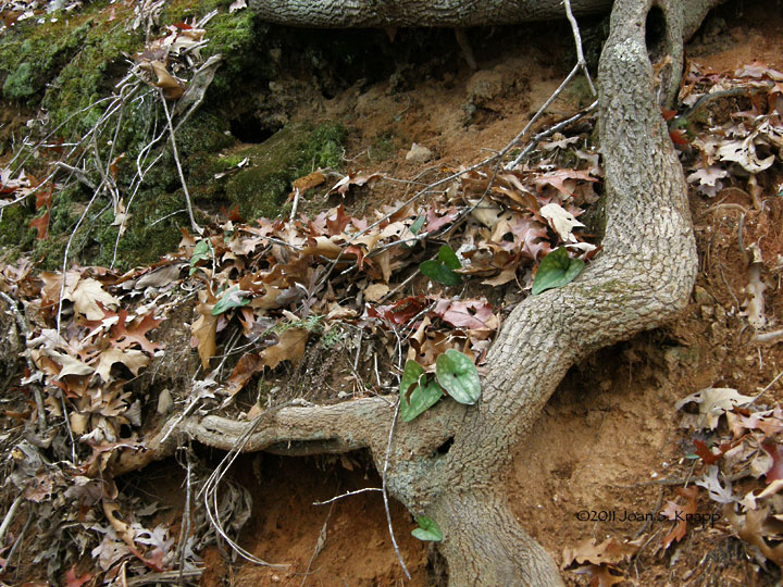
 As we descended further, we noticed a lot of plants of Hexastylis sp, probably H. arifolia (Wild Ginger or Littlebrownjug). We’ll have to wait until next Spring to confirm the species. I’ve never seen these growing on the side of such a steep embankment before.
 A closer view of the leaves
 The descent became much steeper. We’d descend quite steeply for a short distance to meet a ‘berm’ we couldn’t see over to know how steep the next section would be. Looking up one of these sections as we climbed back up the road.
 The ledge above the Etowah River was flat and rather forlorn in the cloudy weather. It will be interesting to see what develops in the warmer weather.
 On the way back up the road, an unusual leaf shape on an embankment caught my eye. There are several plants in this photo.
 A closer view. Hepatica nobilis var. obtusa (Round-lobed Hepatica or Round-lobed Liverleaf). These are easy to identify from the leaf shape. They should bloom in March so it will be fun to come back to see the flowers then.
 When we returned to the junction of Clark Road, we drove down Railroad Rd. We saw several patches – some quite large – of Lycopodium digitatum (Fan Clubmoss, Common Running-cedar, Fan Ground-pine, Common Running-pine). I never cease to be fascinated by these plants
 A few plants were beginning to fruit.
From here, we drove up Shoal Creek Road to complete our visit to the City of Atlanta Tract of the Dawson Forest WMA.
Click on an image to view a larger image
Distribution:
United States Department of Agriculture Plants Database:
- Viola pedata (Birdsfoot Viola): [United States] [Georgia]
- Miscanthus sinensis (Chinese Silvergrass): [United States] [Georgia]
- Hexastylis arifolia (Littlebrownjug): [United States] [Georgia]
- Hepatica nobilis var. obtusa (Roundlobe Hepatica): [United States]
- Lycopodium digitatum (Fan Clubmoss): [United States]
University of North Carolina Herbarium:
- Viola pedata
- Miscanthus sinensis - Hexastylis arifolia var. arifolia
- Hepatica nobilis var. obtusa
- Lycopodium digitatum
Identification resources:
Southeastern Flora: - Viola pedata (Bird-foot violet)
- Hexastylis arifolia (Wild ginger, Little brown jug)
Natural and Naturalized Plants of the Carolinas and Georgia:
- Viola pedata (Bird's-foot Violet)
- Miscanthus sinensis (Chinese Silvergrass) - Hexastylis arifolia var. arifolia (Little Brown Jug, Arrowleaf Heartleaf)
- Hepatica nobilis var. obtusa (Round-lobed Hepatica, Round-lobed Liverleaf)
- Lycopodium digitatum (Common Running-cedar, Fan Ground-pine, Common Running-pine)
Related posts:
- Viola pedata (Birdfoot violet)- Wild Ginger (Hexastylis arifolia)
- 2010: Year Of The Wildflower – Wildflower Index
 Shoal Creek Ford. I’m sorry I didn’t take a photo at the top of the ledge before we descended to the creek. It is quite a steep descent, probably two to three times the climb out on the north side ahead of us and there were no guidance regarding the depth of the water. The ford looked quite deep and we sat a while before deciding to cross. W said the water reached the floor boards and the brakes were affected a little so this is a ford to assess carefully before crossing.
 Looking upstream (east) from the ford as we crossed it. The ripples are from our movement; the water was quite still when we began the crossing.
  Looking downstream from the ford. The water is flowing quite rapidly over the curb. The green bushes on the embankment in the distance looked like rhododendrons.
 We saw several seed heads of Asclepias species that we guessed were A. viridiflora (Green Comet Milkweed) based on their stalks. We saw a few near the junction of Clark and Reservoir Roads as well as this one on North Gate Road.
 We found this sign rather amusing although it is quite an important and very, very practical sign. The tract has a complex series of hiking, equestrian and mountain biking trails. Horses and mountain bikers are not allowed to use the road beyond this sign. Horses are travelling slowly enough that their riders would see the small trail marker sign that tells them where the trail leaves the road and that they cannot continue along the gravel road. Mountain bikers, on the hand, would be travelling fast enough down the hill that they would likely miss the trail marker sign but they could not miss this sign.
 I’d never thought much about how Lycopodium digitatum (Fan Clubmoss) plants spread. This image shows the runner system quite clearly.
 We continued down North Gate Rd to the ledge above the Etowah River. The clouds had cleared for a short while and the woods looked a little less forlorn than at the end of Mill Rd.
 North Gate Road ended near this old railway bridge. Only the bridge skeleton remains. It looks like this railroad supplied the Georgia Nuclear Aircraft Laboratory.
 The road is closed at the bridge. The hiking, equestrian, mountain biking trail cross the Etowah River along to the left.
 The sign for the river ford.
 The trail down to the river. There was a very narrow ‘beach’ above the water.
 The Etowah River, looking upstream from the north side of the Etowah River Ford.
 Looking across the Etowah River to the south side of the river. The water varied in depth. It looked about 1.5 to 2 feet deep at a rock-covered bar about one-third of the way across but deeper in other parts. I didn’t feel the water temperature but it looked cold. It would be an interesting crossing walking or carrying a bicycle. This looked like a ford for the summer but not now.