Tuesday, December 28, 2010

Snow: Fort Yargo State Park

I always want to go up to the lake after it’s snowed. However, there are a few steep hills between us and the lake and I hate to risk it if the roads are slippery. The roads were clear in our area by late morning so we drove up mid-afternoon. It was bold and breezy; skies were generally cloudy although the sun broke through a couple of times.

At the boat launch, Section B


Looking from the parking lot towards the pedestrian bridge and the upper end of the lake (segment 18).

Looking east from the parking lot (segment 17).

Walking out to the middle of the bridge to get a better view. Many others had been here too.

Looking east from the center of the bridge. Compare this view with the one I took on December 19th, 2010.

*****
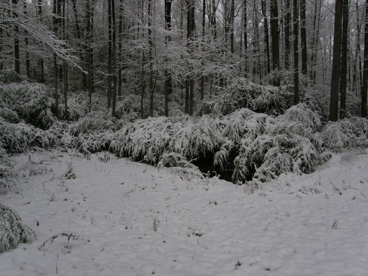
The north side of the lake above the bridge was in the shade and both trees and ground were covered in snow.

At Picnic Area #1


Looking over to Picnic Area #2 (segment 15) which was deserted.

Looking a little further along the shore to the island (segment 16).

Looking over the docks towards the dam (segment 5) which is also in the shade and covered with snow.

Just before we left Picnic Area #1, the sun peaked through the clouds and brightened the tree trunks near us.

At the Old Fort


Looking from the parking lot east across the lake to the area (segment 10a) near the Nature Center. If the lake was full, I’d be able to row up to the edge of the snow in the center of the view.

The Old Fort. Compare with this photograph taken in January 2010.

The stack-rail fence at the edge of the parking lot and the woven garden fence in the background.

Just before we left the park, the sun peaked through again and highlighted the trees below the fort.

Click on an image to view a larger image


Related posts:

- Picnic Area – Old Fort: Part 3. Old Fort - Fishing Area

- Fort Yargo State Park: A Cold, Sunny Day

- First Fall Row

Monday, December 27, 2010

Snow: In The Field

After tromping through the woods, it was time to walk the perimeter of the field out front. Most photos appear to be black and white, but now there’s a little color.

Looking next door.


Looking towards the road. Most of the bamboo, in the middle of the photo, is doubled over under the weight of the snow. It springs upright as the snow melts.

My walk around the field starts with the pathway along the power line right-of-way that serves as a firebreak and a great place to find wildflowers during the year.

Boughs of a small Eastern Red Cedar (Juniperus virginiana) in the field also bend under the snow.

An apple tree has stiffer limbs; the snow simply piles up on them.

Oak leaves - I don't know the species - have blown across the road and settled in the snow at the front of the field.

Stems of Broomsedge (Adropogon virginica) also bend under the weight of the snow. Surprisingly they don’t break but spring back vertical as the snow melts.

An Eastern Bluebird (Sialia sialis) nestbox at the edge of the woods is decorated with snow.

A tall Willow Oak (Quercus phellos) stands surrounded by young Loblolly Pines (Pinus taeda) that have seeded from the nearby woods.

Today the snow is still on the field. The low temperatures persist and the snow is still lying on the field. It will melt in the next day or so as the temperatures rise.

Click on an image to view a larger image


Related posts:
- Snow: In The Woods; A Study In Black And White

- And Then It Snowed: In The Woods

Sunday, December 26, 2010

Snow: In The Woods; A Study In Black And White

The weather mavens tell us this is the first White Christmas in the Atlanta area since 1882. It started to snow on Christmas night. Two to three inches has accumulated by this morning. So… the obligatory walk down to the creek and around the field. The photos were taken in color but the skies were dark and most appear to be black and white. Mostly, anyway.

Heading into the woods.

Each summer, I keep forgetting to cut these Chinese Privets (Ligustrum sinense) back. It’s not until it snows that I remember. The branches sag under the weight of the heavy snow and block the path. I can push my way through but end up covered in snow. Ugh.

On the slope above the ledge by the creek.

On the path along the ledge above the creek. This is one of my favorite spots; I photograph this path repeatedly.

The pool in the opening in the woods. It’s barely visible this year; the Chinese Privets bushes have grown compared with the photograph taken early this year.

The woods behind the pool. The pool is to the right of this photograph.

Retracing my steps along the path above the creek. I tried to walk the circuit but the privets had blocked the path completely and I couldn’t get through.

A view of the back path on the ledge above the creek. It's completely blocked at the far end.

Looking back, from the same spot, to the path I had walked. I can see my footprints in the snow.

And back up the hill to the field.
And on to the field… (to be continued)
Click on an image to view a larger image


Related posts:

- And Then It Snowed: In The Woods

- Woods in the Fall

Friday, December 24, 2010

No Diving!

It seems obvious now. But the lake is starting to fill up again. Water is just covering the center and it won’t be long before it will be deep enough that the bottom won’t be visible and this will be a serious warning. At full pool, the water will only be 4 to 5 feet deep below the bridge.
Click on an image to view a larger image


Related posts:

- Fort Yargo State Park: Shades Of Brown And Green. Part 1

- Fort Yargo State Park: A Cold, Sunny Day

- Fort Yargo State Park: Déjà Vu

Tuesday, December 21, 2010

Fort Yargo State Park: Shades Of Brown And Green. Part 2

The dam was the halfway point of this walk – to see what the lake level was.

The level was about a foot higher than when I last saw it in November. Water wasn’t gushing from the outlet pipe as it has been in November. Perhaps the bridge repairs are completed and the lake level is rising again.


Most of the gulls – Ring-billed Gulls (Larus delawarensis) - had settled on the water in this section of the lake. Periodically they’d take off, fly a few circles and come back in to land, only to settle for a second or two and...

Then fly off again. They’d repeat this several times before settling on the water again. I sat and watched them for a while before starting back to the car

*****
This Great Blue Heron (Ardea herodias) flew in through the circling gulls to land. It uttered a slightly strangled ‘urk’ – not the usual harsh call - as it negotiated its way in. It settled here for a while and then flew a short way along the shoreline to fish.

More shades of brown along the trail.

Mosses cover rotting logs along the trail.

At about this point, I left the trail and walked back along the beach (beige trail on map). Once the lake fills, the
beach will disappear under water again.


The fish attractors that were on the point between the dock and the beach have gone. They’ve been dropped into the lake in the last week.

Some of them were dropped out from the shore at the east end of Picnic Area #2..

A sprig of Loblolly Pine (Pinus taeda). We had some windy weather last week and there were several sprigs decorating the trail.

Some Broomsedge (Andropogon virginicus) still held seeds that seemed to glisten in the sun.

Back at the parking lot. Looking back at the pedestrian bridge with the sheets of plywood laid across the bottom of the lake to allow the workers to replace the cross-braces without sinking deep into the soft mud-sand mixture. Soon this will be back under water.
Click on an image to view a larger image


Related posts:
- Fort Yargo State Park: Shades Of Brown And Green. Part 1

- Fort Yargo State Park: A Cold, Sunny Day

- Fort Yargo State Park: Déjà Vu

- Ring-billed Gulls (Larus delawarensis)

Sunday, December 19, 2010

Fort Yargo State Park: Shades Of Brown And Green. Part 1

I haven’t walked the south side of the lake for a month or so. So that’s the way I went today.

I crossed the pedestrian bridge from the parking lot and followed the trail to the gas pipeline right-of-way and then back into the woods along the lake shore. The trail goes inland to avoid a deep gully and climbs a steep hill. At the top of the hill it drops back down the the lake shore. Another trail goes off the the right and works its way towards the gas line right-of-way without reaching it and finally joins the other trail at the end of the dam.

Looking to the east just after crossing the pedestrian bridge from the parking lot. The stonework in the lower right hand side is the approach to a bridge that crossed a creek before the valley was flooded to create the reservoir.

A little further along the trail. Again, looking east towards the campground on the east shore of the lake where the yurts are located.

I’ve just climbed the first hill and am looking north-north-east towards Picnic Area #2. The pine trees are one source of color now that most deciduous trees have dropped their leaves and the grass has turned brown.

The trail just as arrive at the gas line right-of-way

The painted blazes marking the different hiking trails provide some color.

Looking back towards the pedestrian bridge at the parking lot.

A large bank of Christmas Fern (Polystichum acrostichoides). This fern occurs in many gullies on along this trail but this is the largest area of fern.

A close up of the fern.

The trail along the lake. Most of the trail looks like this at the moment.

One of the few oaks that hasn’t lost its leaves yet.
(To be continued…)

Click on an image to view a larger image


Related posts:

- Fort Yargo State Park: A Cold, Sunny Day

- Fort Yargo State Park: Déjà Vu