Showing posts with label Walking. Show all posts

Monday, February 21, 2011

Gwinnett County: Little Mulberry Park – East Meadow Trail (Part 2)

The East Meadow Trail circled the meadow and then ran along just inside the edge of the woods. It emerged for a short distance before diving back into the woods for the final quarter mile.

The woods were mostly bare with several downed tree trunks.

Some smaller trees, including this American Beech (Fagus grandifolia) hadn’t lost their leaves and broke the monotony of bare trees.

This was one of the few ‘bushes’ in the woods.

A closer look. It was more a series of long thorns with connecting stems. It didn’t have any leaves. I know I’ve seen photos of it somewhere but can’t remember what it is. Can anyone help me identify this plant?
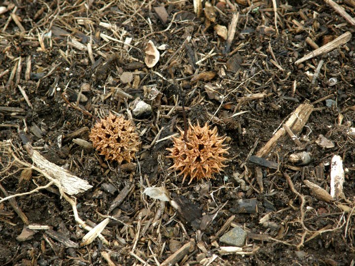
A couple of Sweetgum (Liquidambar styraciflua) seedpods. The ground was littered with them.

Clumps of wild onions dotted the landscape. I’ve never seen these bloom. Looked like something had nibbled on these.

The East Mulberry Trail, which had crossed the open meadow entered the woods again.

Another fallen tree. The trunk was covered with bracket fungi, probably Turkey Tail (Trametes versicolor), which is common in these woods. These were well past their prime.

The Carriage Trail (D), a paved, multi-use trail, connects the meadow trails with the Miller Lake Trail.

More leave. A maple tree this time.

Another American Beech tree by the trail. There were a lot of small trees in this area with leaves still attached. These were a welcome change from the bare woods.

A close up of their leaves.

There were also several holly trees in this area of the woods.

And mounds of moss. This was the most impressive mound.

Almost at the end of the East Meadow Trail.

The mile marker at the end of the trail.
Click on an image to view a larger image


Resource:

- Gwinnett Parks and Recreation: Little Mulberry Park


Related posts:

- Gwinnett County: Little Mulberry Creek Park – East Meadow Trail (Part 1)

- Gwinnett County: Little Mulberry Creek Park – West Meadow Trail

- Gwinnett County: Little Mulberry Park – Miller Lake Trail

Saturday, February 19, 2011

Gwinnett County: Little Mulberry Park – East Meadow Trail (Part 1)

When I got to the 0.75-mile marker where a trail connects the West Meadow Trail to the East Meadow Trail, I decided I had time to walk the East Meadow Trail too.

The East Meadow Trail is paved but seems to be more intimate than the West Meadow Trail. The trail winds a little more and threads its way among small clusters of trees. Some areas have been mowed but most of the area is natural.

A trail begins by winding through some woods.

As the trail starts, a cross-country trail goes straight ahead.

Once out of the woods at the beginning, the trail winds through an open area dotted with trees. The sign on the left states: Meadow Restoration.

The cross-country trail wound around the end of the woods where the trail began and crossed the paved trail. It then followed the mowed path along the edge of the woods. I’m not sure where it went; that has to wait for a future walk.

A view to the southeast. Although there is a small subdivision just outside the park boundary, the view from the trail is rural.

The trail winding through another cluster of trees in the open meadow.

A Common Mullein (Verbascum thapsus) plant that survived the winter in the open. New leaves are developing.

The trail winds though more trees. This turned out to be a special spot on this walk.

A characteristic rosette of Hairy Bittercress (Cardamine hirsuta) in bud. I wasn’t really looking for wildflowers. It seemed a little early to expect any. But there it was! There were a few plants starting to bud. They were in a spot that would get an hour or so of sun in the middle of the day but were protected from radiant cooling at night. (I’d seen some rosettes in protected areas around our house. When I got home, I checked and found a single plant starting to bud). Spring is on the way.

A closer view. The purple colored stems of the young plants makes them easy to spot.

At about the mid-point of the trail, the path moved into the open. Here, the East Mulberry Trail enters the
meadow from the woods to the northeast. It’s an un-paved path – an equestrian trail that crosses the meadow before it exits back into the woods to the northwest.

The sign for the East Mulberry Trail warns of its steepness.

The trail winds along the meadow at the edge of the woods.

A view from the meadow to the southwest.

A sentinel tree in the meadow just before the trail winds back into the woods.

(To be continued)

Click on an image to view a larger image

Resources:

- Gwinnett Parks and Recreation: Little Mulberry Park

- Southeastern Flora: Common Mullein (Verbascum thapsus)

Related posts:

- Gwinnett County: Little Mulberry Creek Park – West Meadow Trail

- Gwinnett County: Little Mulberry Park – Miller Lake Trail

- Hairy Bittercress (Cardamine hirsuta)

Wednesday, February 16, 2011

Gwinnett County: Little Mulberry Park – West Meadow Trail

Why? Why? Why? Why? Why? Why? Why? Why is it cloudy every time I go to check out a new trail? Anyway, I was headed over to Buford along GA-324 which goes right by the roads that lead to Little Mulberry Creek Park. Previously, I walked the Miller Lake Trail. Last Friday, I left home early to walk the West and East Meadow Trails before I went on to Buford. The weather forecast indicated partial sun from 8:00 a.m. on until the skies cleared. But it was cloudy. Never mind. Sometimes it’s easier to photograph in overcast weather than in bright sunshine.

I wanted to explore the meadow trails that are accessible from the Fence Roa
d entrance to the park.

I decided to walk the West Meadow Trail and decide when I got to the trail to the East Meadow Trail whether to take the latter or just walk the first trail. As it happened I had time to walk both. It took 1.5 hours walking at a moderate pace and stopping to take many photos.

The West Meadow Trail. The darker green areas in the meadow have been mowed. I saw a sign for the observatory (E) when I started out on the trail. It’s on the top of the hill in the center of the meadow. If you walk the trail clockwise, the hiking trails – the Ravine Loop (B) and the Beech Tree C trails – branch off from the loop trail within the first half-mile. The trail (F) to the East Meadow Trail leaves this trail at the 0.75-mile marker.

A trail marker for the West Meadow Trail. It’s a multi-use, paved trail shared by walkers and cyclists.

This is the entrance to the Beech Tree Trail (C). The entrances are clearly marked; there’s no way to miss them.

A trail map at the entrance to the Beech Tree Trail. It’s difficult to see in this photograph but the map is a topographical map that shows the steepness of the trail. It’s a good idea to study this if you don’t feel up to an energetic hike. Some of the grades are 12% according to the information on the sign. Glad I didn’t plan to do this hike on this visit to the park.

This trail is intended only for walking. Bikes are not allowed.

The start of the Beech Tree Trail. It’s well surfaced with gravel and obviously intended for heavy travel.

Looking northeast from the trail towards an area that has little development.

From this point, I walked up the hill to the observatory that is a flagstone circle with two hemispherical benches.

Cardinal points – N (North), S (South), E (East) and W (West) – are painted on the flagstones just inside the bench.

Tracks of the ubiquitous possum. A series of animal tracks have also been marked across the circle.

In the overcast weather, the meadow and woods were rather bleak. It was good weather for walking though; it wasn’t raining or windy.

A flock of Eastern Bluebirds (Sialia sialis) were hunting in the grass at the eastern end of the meadow. They were teasers; they would sit until I almost got into a good position to photograph them and then they’d fly just a few feet further away.

I started to call a couple of rows of pine trees – a five on the north side and five towards the south side (D) - ‘The Sentinels.’ One or other of them seemed to dominate the skyline at any point along the trail.

Looking back along the trail at the 0.75-mile point. A covered picnic area with a BBQ stand is on the right and the northern sentinel pines are in the distance.

Looking south from the trail near the 0.75-mile marker towards the Pond Trail and the farm across the road from the park.

The path near the end of the West Meadow Trail.

This is a great trail to walk in the winter although it might be a little unpleasant in windy weather. I expect that it could be uncomfortable in the middle of the day in summer since it would be in full sun all day.

Click on an image to view a larger image


Resource:

- Gwinnett Parks and Recreation: Little Mulberry Park

Related post:
- Gwinnett County: Little Mulberry Park – Miller Lake Trail