December 28th, 2011. Between Christmas and New Year we took an overnight trip down to the Savannah National Wildlife Refuge in search of some sun and warmer weather. The weather was a little cool due to a northwesterly wind but it was sunny. The Savannah NWR is located on the east side of the Savannah River in Jasper County, South Carolina, just across the Savannah River from Georgia. We visited Argyle Island that is accessed from Alligator Alley.
 In the 1800s, the island was the site of a large rice plantation. The outlines of the rice fields are clearly visible in the satellite image from Google maps. Dikes were built up to provide a drive, the Laurel Hill Wildlife Drive, a 4.5-mile drive, around the freshwater marsh on the south end of the island. Wooden gates, called trunks, were used to control water to the rice fields. These are used now to keep the level of the water in the freshwater marsh constant and immune from the tidal changes in the Savannah River.
We visited the area first in the late afternoon on December 28th and, again, the next morning. These photos are from the late afternoon drive and capture the textures of the grasses and vegetation in the waning light.
 The entrance to the Laurel Hill Wildlife Drive off Alligator Alley.
 Looking across the fields near the beginning of the drive. The structure in the center is one of the wooden trunks that controlled water to the rice fields.
 A closer view of another trunk in a dike at the west end of the marsh.
 Looking across the marsh.
 Looking west towards the container port, Port Wentworth. It was fascinating to see signs of civilization in the distance while driving through the relative wilderness of the marsh. The canal beyond the marsh is clearly empty at low tide.
 The drive passed through a small grove of trees covered in Spanish Moss which is not a moss, but a bromeliad, Tillandsia usneoides. I’ve never seen this plant bloom but there’s a photograph of the flower here. These are relatively small plants compared with some that can be found on the coastal plain.
From the grove the road swung around to follow a canal east and then north to the exit from the marsh.
 Cattails had gone to seed.
 Looking towards woods beyond the marsh.
 Looking back. The woods on the left are the grove of trees we had driven through.
 Woods had developed along some of the dikes.
 Looking across the canal at the south end of the marsh.
 Looking west across the marsh towards a paper mill in the distance.
 Zooming in for a closer look at the paper mill.
 We were intrigued by the shape of the plants growing in the open water.
 Up close, they looked like little trees.
We left the marsh for the night with plans to return the following morning.
Click on an image to view a larger image
Resources:
- US Fish and Wildlife Service: Savannah National Wildlife Refuge
- University of South Carolina, Longleaf Environmental Learning Center: Spanish Moss (Tillandsia usneoides)
December 19th, 2011. After some cool weather, the days were pleasantly warm and we took a trip through north Georgia, just to see what we could see. We began in Helen in Hall County and drove north on the Richard B. Russell Scenic Highway with a side trip up Brasstown Bald. From Brasstown Bald, we drove north to Hiawassee and then west through Blairsville to Blue Ridge.
 From Blue Ridge, we drove south on Aska Road, then north on CR-8 (Newton Road), east on Dial Road, and then south on CR-218 (Double Gap Road) to its junction with Forest Service road, FS-58. We drove southeast along forest service road, FS-58, as it followed Noontootla Creek to its headwaters. At the end of FS-58, we turned west on FS-42 to the Springer Mountain parking area for the sourthern terminus of the Appalachian Trail. From here, we drove northwest along FS-42 back to CR-218.
 A typical view from the road towards Noontootla Creek. The creek flows through a deep gorge in pine forest with a rhododendron understory. For most of the drive it was difficult to see the creek.
 We saw embankments with wild ginger plants
 A brief view of the creek through the trees
 A closer view
 There were occasional open areas under trees along the creek bank. The creek is subject to a restoration effort. Many open areas had no parking access; picnicking, but no camping, was permitted at a couple of areas; and camping was permitted at only two areas above the creek.
 One of the few open views
 A closer view of the water flowing over the rocky creek bed.
 One of the open areas where picnicking was permitted.
 A wild ginger (Hexastylis sp.) plant among the trees
At the end of forest service road, FS-58, we turned west onto FS-42. As we looked down from the road, we saw several springs below us. These would coalesce to form Noontootla Creek.
 At the Springer Mountain parking area for the southern terminus of the Appalachian Trail.
 The information kiosk for the Appalachian and Benton MacKaye Trails
 The Appalachian Trail actually begins on Springer Mountain, 0.9 miles south of the parking area. The Benton MacKaye trail - that follows a 300-mile route through Georgia, Tennessee to Davenport Gap in North Carolina - also begins here.
 The Appalachian Trail leaves the Springer Mountain parking area here.
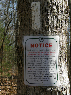 A notice, just a little along the trail from the parking area warns that Black bears are active in the area and gives guidance for storing foods beyond their reach.
From here we continued along forest service road, FS-42, to CR-218 before returning home.
 A lichen on rocks. This is probably Umbilicaria mammulata which, according to the lichen guide - guide to twelve common and conspicuous lichens of Georgia’s Piedmont – is a brown, foliose lichen with one attachment point at the center. It grows on rocks, as these were, and on mountain cliffs on Mount Yonah in White County. These lichens were about 12 inches in diameter and had pealed off the rock to reveal black backs.
 A closer view.
 Another lichen. One of the yellow-gold lichens.
 A closer view.
The Noontootla Creek area will be worth visiting in the Spring when the rhododendrons and other wildflowers bloom.
Click on an image to view a larger image
Resources:
- ScenicUSA - Georgia: Noontootla Creek-
Appalachian and Benton MacKaye Trail Maps: Georgia, Tennessee and North Carolina
- Lichens: A guide to twelve common and conspicuous lichens of Georgia’s Piedmont
Related post:
- Over The Hills And Through The Woods: Raven Cliffs, Bob’s Creek, And Brasstown Bald
December 18th, 2011. After some cool weather, the days were pleasantly warm and we took a trip through north Georgia, just to see what we could see. We began in Helen in Hall County and drove north on GA-348, known either as the Richard B. Russell Scenic Highway or the Russell Brasstown Scenic Byway. At the south end, the highway forms the eastern border of the Raven Cliffs Wilderness.
 The road, in the Raven Cliffs area gives vistas to the east.
 Water seeps down the rock wall created when the highway was built. A small patch of icicles that resulted from the cold weather a few days earlier.
 Further north, we started to see rhododendrons on the hillside below the pines
 The Appalachian Trail crosses the highway at Hog Pen Gap
 Further north, more roadside cuttings with icicles. These cuttings remain in the shade so the icicles persisted even when the temperatures rose into the 60s F.
 And vistas to the north
At the end of GA-348, the scenic highway continues northeast on GA-180. We took a short side trip along Forest Service Road 292. This is a gravel road that wound around the hillside. At one point, the road crosses Bob Creek. There is a wide, inviting ledge on the north side of the creek. A local man told us this had been an Indian camp. It was easy to imagine this as a pleasant summer camp in the hot Georgia summer.
 Looking upstream along the creek. Part of the ledge is visible to the left.
 Looking downstream.
 We saw more banks of Fan Clubmoss (Lycopodium digitatum)
 Some had fruited.
We continued on and decided to drive up Brasstown Bald which is the highest point in Georgia. The area was inhabited by the Cherokee Indians who called the mountain Enotah. Early settlers confused the Cherokee word itse-yi ("Place of fresh green") with untsaiyi ("brass") and called the mountain Brasstown Bald. A bald implies a 360-degree view from the site. The road ends in a parking lot and one must hike to the summit. Needless to say, we didn’t hike to the top.
 The visitor center at the summit of the mountain.
 The clear vista to the west. The vista to the east from the parking lot is blocked by the trees.
It was late in the day. From here, we drove north to Hiawassee and then west to Blairsville and Blue Ridge where we spent the night before continuing our overnight trip.
Click on an image to view a larger image
Resources:
- Sherpa Guides: Russell Brasstown Scenic Byway
- Around North Georgia: Brasstown Bald
December 9th, 2011. We were making our way back along the north shore of Lake Rutledge in Hard Labor State Park in Morgan County, Georgia, when I saw what looked like a duck with a white front preening itself on a long just off the shore. It was strange that it sat there when all the previous ducks we’d seen had flown off the minute they spotted us. At about the same time, a Bald Eagle (Haliaeetus leucocephalus) flew across the lake and settled in the branch of a pine tree just above the log.
We decided to drift along the shore and see how close we could get to the ‘duck’ as well as seeing if we could spot and photograph the eagle. Quite often, it’s useful to identify objects by taking a photograph using full zoom and then enlarging it in the preview window on the camera. And this is what we saw. A Northern River Otter (Lontra canadensis) with a fish in its mouth. The otter was lying along the log. The fish was what had looked like a white front on the ‘duck.’
 A cropped enlargement of the first image. It’s an adult otter, 3 to 4 feet in length. The fish is large too.The otter slid back into the water and appeared on the left side of the tuft of grass at the left side of the first image. Just its head was above water. Then it disappeared under the water again. We thought this would be the last we’d see of it.
 It then reappeared midway along the log again. Just its upper body visible above the log this time. I think it was having some difficulty managing the fish. The grayish sheen on the face and throat are visible in this shot.
 This shot, the last we were able to get, shows the otter’s head, side-on, with the fish still in its mouth. Its holding onto the log with its short front, left leg. Clearly this otter is healthy and well fed.The otter then disappeared. The next we saw it, it had swum underwater about 20 to 30 yards west along the shore and appeared briefly in the water before it climbed out onto the shore and took its fish off into the bushes to eat. We wondered if the Bald Eagle had seen the otter with the fish and had flown across the lake, hoping to steal a meal. Soon after the otter took its fish into the bushes, the eagle flew back across the lake and out of sight. Maybe this scene with eagle and otter is played out frequently.
This is the first time I’ve ever seen a Northern River Otter. The photographs aren’t the best, but not bad for the limiting light conditions, the distance from the otter, and the speed with which these events occurred. We’ll be returning to Lake Rutledge in the future in hopes of seeing this otter again.
Click on an image to view a larger image
Resources:
- Hard Labor State Park
- University of Georgia Museum of Natural History: Northern River Otter (Lontra canadensis)
Related post:
- Hard Labor State Park: The Many Moods Of Lake Rutledge
 In the 1800s, the island was the site of a large rice plantation. The outlines of the rice fields are clearly visible in the satellite image from Google maps. Dikes were built up to provide a drive, the Laurel Hill Wildlife Drive, a 4.5-mile drive, around the freshwater marsh on the south end of the island. Wooden gates, called trunks, were used to control water to the rice fields. These are used now to keep the level of the water in the freshwater marsh constant and immune from the tidal changes in the Savannah River.
 The entrance to the Laurel Hill Wildlife Drive off Alligator Alley.
  Looking across the fields near the beginning of the drive. The structure in the center is one of the wooden trunks that controlled water to the rice fields.
  A closer view of another trunk in a dike at the west end of the marsh.
  Looking across the marsh.
 Looking west towards the container port, Port Wentworth. It was fascinating to see signs of civilization in the distance while driving through the relative wilderness of the marsh. The canal beyond the marsh is clearly empty at low tide.
 The drive passed through a small grove of trees covered in Spanish Moss which is not a moss, but a bromeliad, Tillandsia usneoides. I’ve never seen this plant bloom but there’s a photograph of the flower here. These are relatively small plants compared with some that can be found on the coastal plain.
 Cattails had gone to seed.
 Looking towards woods beyond the marsh.
 Looking back. The woods on the left are the grove of trees we had driven through.
 Woods had developed along some of the dikes.
 Looking across the canal at the south end of the marsh.
 Looking west across the marsh towards a paper mill in the distance.
 Zooming in for a closer look at the paper mill.
 We were intrigued by the shape of the plants growing in the open water.
 Up close, they looked like little trees.


