We’d had several cloudy, gray days during the ‘big snow.’ Cabin fever was setting in. Then the sun broke through and we had to get out. It was cold but the sun made up for it.
 We drove down to Jasper County where we criss-crossed the Oconee National Forest. This photo was taken as we crossed a tributary of the Little River. It looks warmer than it was but we enjoyed the sun.
Click on the image to view a larger image
 We had a few hours so we went by Charlie Elliott Wildlife Center and, as always, stopped by Whitetail Lake. The deciduous trees aren’t showing any sign of budding yet. But wildflowers are starting to bloom.
Dandelions (Taraxacum officinale) were blooming under the slip-rail fence by the parking lot. The Henbit (Lamium amplexicaule) was in bud, not far from blooming. Shepherd’s Purse (Capsella bursa-pastoris) was also blooming. Unfortunately someone had trimmed the grass under the fence and I only found one bloom of Shepherd’s Purse. Several plants were blooming under the fence at Teal Lake. None of the plants had developed the characteristic heart-shaped seedpods.
Charlie Elliot Wildlife Center is the only place where I’ve seen Shepherd’s Purse in this area. I’m sure I just haven’t looked closely enough in other areas. But it’s time to start looking seriously now.
Click on an image to view a larger image
Related posts:
- Charlie Elliot Wildlife Center: Whitehall Lake
- Whitetail Lake: Wildflowers
- Henbit (Lamium amplexicaule)
It started early in the evening as freezing rain. Sharp snapping sounds of sleet hitting hard surfaces. When I first poked my head out the front door, there was barely anything sticking to the walk; just patches of ice pellets. A couple of hours later, I poked my head out again and there were about three inches of snow and it was coming down heavily. Small, dry flakes like it does when it’s really cold.
In the morning… The bird feeders were fully occupied. These are mainly finches and Pine Warblers. But House Finches, Chickadees, Titmice, and Cardinals are frequent visitors. It was interesting to note that the Cardinals, in spite of the fact that they are twice the size of the others, don’t fly in and force the other birds off the perches; they wait their turn.
 The trunks of trees by the walk. Drifts of a foot or so accumulated under the trees.
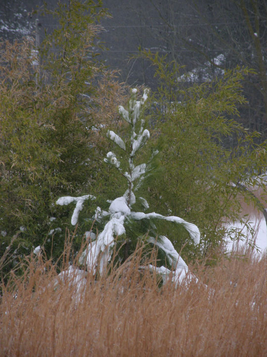
 Across the field. Unlike the previous snow that was wet and heavy, this snow was powder and, for the most part, didn’t weigh down the bamboo or the Broomsedge (Andropogon virginicus) grass. About an inch of ice accumulated on the power line; luckily it didn’t break the line.
 *****
***** Snow on the Rav. Almost five inches had accumulated on the spare tire cover. Some may have blown off in the strong wind. I measured 6 inches on a surface that was protected from the wind. First time I’d used the measure that W had bought me for just such a purpose.
 The recliner out in the field. Don’t think I’ll be using this for a few days.
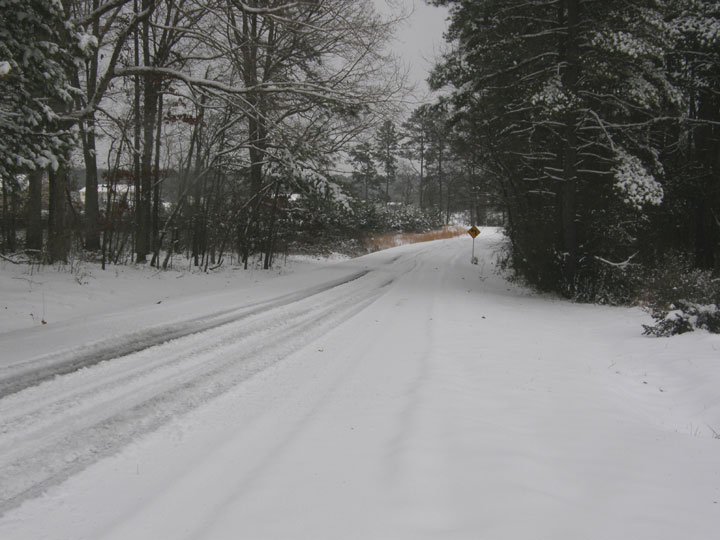
 At the road. A few intrepid drivers had made their way down the road - but only a few.
 But no tell-tale tire tracks to the mail and paper boxes. No deliveries today.
 The snow that did accumulate on the trees gave them a strangely contorted appearance due to the frozen rain that held the snow to the branches.
 Footsteps in the snow. It was a hard walk to the road. There was a thin crust of ice on the surface of the snow. If I put my foot toe-first into a step, the ice would ‘grab’ my foot and trip me. I had to place my feet vertically into the snow to avoid tripping.
This snow is going to hang around for a few days. It’s not going to get above freezing for another three days. A rare event in these parts.
Click on an image to view a larger image
Related posts:
- Snow: In The Field
The areas of the park I had walked so far were open and relatively dry. Although it was sunny when I started out, the clouds had rolled in and the sky was gray. This post covers the trail I walked from the second footbridge to the end of my walk.
From the second foot bridge, the trail climbed up the ridge and continued through though dry, open woods again. It wound around the top of the ridge before curling around and back down to the emergency exit trail. The trail then curved south to a viewing platform that overlooked the Alcovy River before heading back north to the trailhead.
 *****
***** This tree beside the trail up to the ridge from the footbridge had two scars from blazes that had been made many years ago.
 Some cyclists passed me at the top of the ridge.
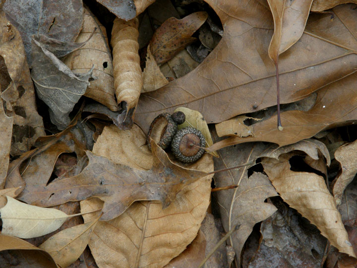
 The ground was covered with oak leaves. Acorns scattered among them lent pretty patterns to the forest floor. Although they were small, they did stand out among the leaves.
 The trail heading north towards the emergency exit trail. For some reason, the embankment added a pleasing accent to the line of the trail.
After passing the emergency exit trail, the hiking trail turned south to the viewing platform above the Alcovy River. The ecosystem here was also strikingly different from the surrounding woods. It was quite a surprise to emerge into an open area with a boulder floor.
 Immediately to the left was a carpet of Reindeer lichens (Cladonia sp.) and some Yucca plants, some of which had bloomed judging by the dead flower stalks.
 The trail turned right to a large viewing platform that could accommodate many people.
 Another carpet of lichen and Yucca plants lay on the north side of the platform.
 The Alcovy River flows eastwards in the valley on the south side of the platform. I suspect the river might overflow its banks in this area after a heavy rainfall.
 Cedars are the dominant trees in this area.
 After leaving this area, the trail winds north back into the drier, deciduous forest. Several dead trees have been felled in this area relatively recently.
 A hollow log is a rare sight. Most felled trees have solid trunks. And I saw two hollow trunks in the same general area on this trail.
This hike would have been pleasant on a warmer day and if the trail had been a little drier. On this particular day, the wet trail made travel slower and more difficult. It was getting late, the temperature was falling and the wind was chilling. I didn’t know the terrain on the remainder of the hiking trail so I didn’t know what lay ahead of me if I continued. At the point where the hiking trail almost met the equestrian trail I’d walked the previous day, I knew where I was and traced my way back to the emergency exit trail and then to the trail head.
 The emergency exit trail is a roadway through a Loblolly Pine forest and provides a ‘straight line’ route to the trailhead. Obviously I’ll have to go back and complete the hiking trail.
Harbins Park has enormous potential for walking. Between the equestrian trail I walked – and there are others, the hiking trail, and the emergency exit trail, it’s possible to ‘mix and match’ sections of these trails to accommodate available walking time and to vary the scenery on any particular walk.
Gwinnett County is to be commended for their investment in this park. The park planners did a great job in developing winding trails that maximize use of the available area without making the trails feel crowded. The trails are well signed and maintained. And, I discovered at the end of the walk, printed maps of the park were available in a box by the map at the entrance; I had completely overlooked them. Kudos also for restrooms that are open in the winter months.
Click on an image to view a larger image
Resources:
- Gwinnett County Government: Harbins Park
Related posts:
- Gwinnett County-Harbins Park: Hiking Trail. Part 1, Trailhead To Footbridge #1
- Gwinnett County-Harbins Park: Hiking Trail. Part 2, Footbridge to Footbridge
- Gwinnett County-Harbins Park: Trail Trip #1 (Part 1)
- Gwinnett County-Harbins Park: Trail Trip #1 (Part 2)
 We came around a corner where the road dropped down to cross a creek in the Stalking Head Creek area in the Oconee National Forest. Off to the north was a pond as big as the ones in the Piedmont NWR. It was a pretty pond.
 And it was a well-established pond. Duck nesting boxes had been placed at several locations around the pond. They’d obviously been there for some time.
 The dam on this pond was at least four feet high. As we dropped down to cross the creek the top of the dam was at eye level. We had to stretch our necks to see over it.
  But it wasn’t an earthen dam; it was a beaver dam. This one was quite impressive - on of the tallest beaver dams I've seen.
 A closer look at the dam. The branches were only 1-1/2 to 2 inches in diameter.
  Downstream, immediately below the road crossing, there was more evidence of beaver activity. When I took this photograph, I had seen only the tree in the center of the photo that had been felled at least a year ago. When I processed the photo, I saw the second tree, in front of the first tree I had seen; this second tree had been felled at least a year earlier than the first tree. These trees were at least one foot in diameter.