May 12th, 2012. Milkworts have been blooming.
 Polygala polygama (Racemed Milkwort). The Racemed Milkwort is probably the most widely distributed milkwort in Georgia.
 A closer view of individual flowers
Another milkwort that appears to be rare in Georgia is Boykin’s Milkwort (Polygala boykinii). We saw a few plants in bloom beside the Red-cockaded Woodpecker Trail in May 2011. Just a few plants. This year, as we stopped along Starr Road, still in Jasper County, before we reached the Piedmont NWR, W spotted a patch of Boykin’s Milkwort plants beside the road.
 A cluster of spikes seen from the truck. It’s easy to see how they might be overlooked.
 A little closer, and…
 closer still.
 The leaves near the top of the spike are clearly alternate but...
 are arranged in sets of five near the bottom of the spike.
 *****
**********
*****
 Closer views of the spike. Individual flowers are between 1/4 to ½ inches across.
 *****
**********
 Closer views of the flowers. It was windy that day and difficult to get good shots of the individual flowers. These flowers are only about ¼ the size of the flowers of the Racemed Milkwort.
Polygala boykinii (Boykin's milkwort) is native of the United States where it’s found only in Tennessee, Georgia, Florida, Alabama, Mississippi and Louisiana.. In Georgia, it’s only been documented officially in a few counties - Houston, Randolph, Baker, Decatur and Seminole – in southwest Georgia. Our finds in Jasper and Jones counties would place this species two counties north of Houston County.
Click on an image to view a larger image
Identification resources:
Southeastern Flora: Polygala boykinii (Boykin's milkwort)
Distribution:
United States Department of Agriculture Plants Database: Polygala boykinii (Boykin's milkwort)
Related post:
- Racemed Milkwort (Polygala polygama)
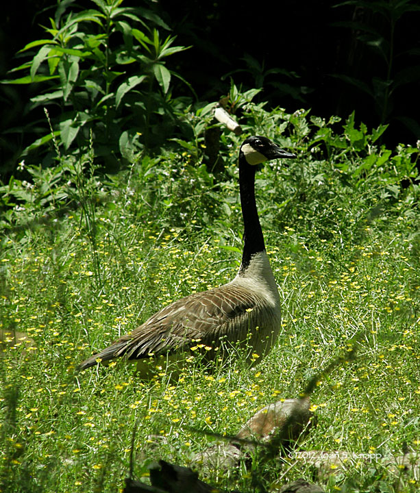
May 11th, 2012. Continued from here. For my money, Canada Geese are among the best parents in the world. I’ve had a couple of opportunities to observe them moving their goslings from place to place at Fort Yargo State Park. We spotted a pair of geese from the river and decided to go over for a closer look. We weren’t thinking much about them having goslings so we were in for a treat. At the river bank, we were only about 15 feet from them.
 The gander was alert but didn’t seem at all perturbed when we got to the river bank. Probably because, even standing in the boat, my head would have been barely above the ledge. The goose was in sight but she wasn’t paying attention to us at all; she was grazing. She was also limping. Another reason for the gander to be watchful.
 A gosling with the goose. Within a few seconds, we realized that they had two goslings. The plants were tall enough that we couldn’t see them at all when they were heads down, grazing.
 A better view of one of the goslings.
 Believe it or not, there are two goslings directly behind the gander.
 The goslings were continually on the move.
We watched for a while and then backed out into the river. Then...
 the goslings came down the bank and…
 into the water where they got a drink and floated near the bank for a few minutes before…
 they returned to the shore and…
 clambered back up the bank where…
 they settled into the grass to nap.
What was interesting about this encounter was that the gander, although watchful, didn’t appear to express any concern about us being at the bank or see us as a danger when the goslings ventured down into the water. He moved a little closer to the edge of the ledge but didn’t make a sound.
Next: Great Blue Heron
Click on an image to view a larger image
Identification resources:
Cornell Laboratory of Ornithology: Branta canadensis (Canada Goose)
Related posts:
- Running The Oconee River: North from Dyar Pasture
- Canada Geese: Family Outing
- Canada Geese: Safety Patrol
May 11th, 2012. We launched at the boat ramp at the Dyar Pasture Recreation Area off SM Copeland Road in Greene County. We headed north to see how far we could go. Since we’ve had a drought for several years, the river level is lower than normal. In addition, the Oconee River drains into Lake Oconee. Georgia Power generates hydro power at the dam at the southern end of the lake. They pump water back into the lake. As a result the level of the lake may lower by a foot or so when power is being generated.
 Our route
 Looking towards a dock at a wildlife viewing area behind an impoundment just north of the boat ramp. This is part of the Dyar Pasture Recreation Area.
 Vegetation comes right down to the water along undeveloped sections on the river. The land to the right (east) is part of the Oconee Wildlife Management Area.
 A closer view of the shoreline along this section of the river; cattails on the left and Devil’s Walkingstick (Aralia spinosa) in bloom on the right.
 Another section of the river.
 We were being watched. The left (west) side of the river is private property with fields coming down to the river.
 As the river flows around bends, sand banks are created in the inner bend of the river. Vegetation has grown on these banks.
 The river narrows further north. The effect of the water erosion is apparent by the height of the vertical bank – at least six to seven feet high, if not higher - on the east side of the river. We had to navigate around fallen tree trunks.
 Catalpa (Catalpa species) trees were blooming. I’m not sure if this was a Northern or Southern Catalpa.
 At some points the forest was relatively open at the rivers’ edge. Had it been possible to go ashore, we could have made our way into the woods.
We were able to travel about four miles up the river. The water was three to five feet deep at the southern end of the trip. Then the water was shallow; we were running in one to two-and-a-half feet for the rest of the trip. The water level was lower on the return trip than on the outbound trip, indicating that power was being generated while we were on the river.Highlights of the trip next…
Click on an image to view a larger image
Identification resources:
Southeastern Flora:
- Aralia spinosa (Devil's Walkingstick)
- Catalpa speciosa (Northern Catalpa)
Name that Plant
- Aralia spinosa (Devil's Walkingstick, Hercules' Club, Prickly Aralia, Prickly-ash)
- Catalpa speciosa (Northern Catalpa, Indian Cigar Tree, Catawba Tree)
- Catalpa bignonioides (Southern Catalpa, Fishbait Tree, Cigar Tree)
 Our route.
 We saw damselflies before we launched the boat. Blue-fronted Dancer (Argia apicalis)
 Heading up river from the Dyar Pasture boat launch
 Dragonfly. I’m not sure what this is. Its wings were deformed; it couldn’t fly.
 Another male Blue-fronted Dancer on a snag.
 Nearby, about a foot away on the same log, a damselfly that looks like a female Blue-ringed Dancer (Argia sedula)
 Then there were the freeloaders who rode up the river on our boat – including what looks like a pair of Blue-fronted Dancers.
 We headed up Fishing Creek. The entrance to the creek was fairly wide but shallow, only about two feet deep in many places.
 *****
***** The creek narrowed. We had to keep an eye on the river depth. Georgia Power generates hydro power at the dam at the southern end of the lake which means that the lake, river and creek levels can fall a foot or so reasonably suddenly. We could have been stranded literally ‘up the creek’ had the power company started generating power. We were lucky though…
 We were treated to an show of Trumpet Vine (Campsis radicans) along the way.
 The creek opens out into a wide, shallow bay. The Pink Queen we saw a year ago is to the left as we entered the bay. This is the entrance to the bay. The rods in the water have ropes with crayfish traps attached. We circumnavigated the bay and encountered this…
 Great Blue Heron (Ardea herodias) high in a tree. It was fanning to cool itself in the hot afternoon.