Showing posts with label Union County. Show all posts

Tuesday, October 2, 2012

Showy or Appalachian Gentian (Gentiana decora)

September 1st, 2012. It was the Labor Day (US) holiday weekend so we took the opportunity to make an overnight trip into the Chattahoochee National Forest. After leaving Dockery Lake, we drove further up GA-60 to the Coopers Creek Wildlife Management AreaCavender Gap Road headed up to a ridge and made its way along the ridge before dropping back down to Cooper Creek and followed it back to GA-60.

It was getting late when we drove down off the ridge and weren’t really taking as much notice as usual in the fading light. But then we spotted some gentian plants on an embankment beside the road. There were probably a dozen plants, each about 18 to 24 inches tall.

The plants were close to the road

A closer view of the top of a plsnt

Flowers lower on the plant

Flowers at the tip of the plant
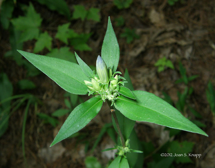
Buds on another stem

An open flower. This isn’t the best photo since the light was low but we take what we can get.

Not being that familiar with gentians, I thought this was Gentiana villosa, the Striped Gentian but as I researched it further, I came to the conclusion that this was Gentiana decora, the Showy or Appalachian Gentian.
 
Gentian decora (Showy Gentian, Appalachian Gentian, Striped Gentian) is native to the United States where it had been documented in southeastern states: Virginia, West Virginia, Kentucky, Tennessee, North and South Carolina and Georgia. In Georgia, it’s been documented only in a few counties in North Georgia including Union County.
Click on an image to view a larger image

Identification resources:
Southeastern Flora: Gentiana decora (Showy Gentian)
Native and Naturalized Plants of the Carolinas and Georgia: Gentiana decora (Appalachian Gentian, Showy Gentian)
Alan Cressler: Gentiana decora
Jim Petranka: Gentiana decora (Appalachian Gentian)

Distribution:
United States Department of Agriculture Plants Database:
Related posts:

Monday, October 1, 2012

Wildflowers: Coopers Creek Wildlife Management Area, Part II


September 1st, 2012. It was the Labor Day (US) holiday weekend so we took the opportunity to make an overnight trip into the Chattahoochee National Forest. After leaving Dockery Lake, we drove further up GA-60 to the Coopers Creek Wildlife Management Area. Coopers Creek Road headed up to a ridge and made its way along the ridge before dropping back down to Cooper Creek and followed it back to GA-60. This road ran through a drier area that presented different wildflowers.


Phlox paniculata (Fall Phlox, Garden Phlox, Summer Phlox, Smooth Phlox)

We found these in many places, particularly on road embankments

Rudbeckia hirta var. hirta (Woodland Black-eyed Susan)
This is my best guess for this flower. Any correction is welcome

The flowers

The leaves

Cantharellus cinnabarinus (Red Chanterelle)
There were clusters of this chanterella beside the road in several places

The cluster

A closer view

Vernonia noveboracensis (New York Ironweed)
http://www.namethatplant.net/plantdetail.shtml?plant=1609

This field was full of ironweed plants

Actaea pachypoda (Doll's eyes)
We saw these from time to time

The leaves were still visible but weren’t in very good shape

Rhexia virginica (Virginia Meadowbeauty, Deergrass, Wingstem Meadowbeauty, Handsome Harry)
We found these plants by the roadside in several areas

*****
*****
The flowers

The leaves

Amphicarpa bracteata (Hog Peanut)
This is a vine that was very widespread

*****
The flowers

The leaves. These had folded down; there are three leaves

Lycopodium digitatum (Fan Clubmoss, Running Cedar, Fan Ground-pine, Running Ground Pine, Common Running-pine)
The Fan Clubmoss occurs in many places in the mountains. They are just starting to fruit.

*****

Arnoglossum atriplicifolium (Pale Indian Plantain)
These were common on roadside embankments

*****
The flowers

The leaves

Stenanthium gramineum (Eastern Featherbells, Common Featherbells)
.We saw a few plants but not nearly as many as at Dockery Lake. This area was drier than the Dockery Lake road.

This stem had bent over under the weight of the flowers. See more photographs here

Next: Gentiana decora (Showy Gentian)
Click on an image to view a larger image

Identification resources:
Southeastern Flora:

Native and Naturalized Plants of the Carolinas and Georgia:
- Actaea pachypoda (Baneberry)

Distribution:
United States Department of Agriculture Plants Database:
 

Related posts:

Sunday, September 30, 2012

Wildflowers: Coopers Creek Wildlife Management Area, Part I


September 1st, 2012. It was the Labor Day (US) holiday weekend so we took the opportunity to make an overnight trip into the Chattahoochee National Forest. After leaving Dockery Lake, we drove further up GA-60 to the Coopers Creek Wildlife Management Area. There was a seep somewhere uphill of the turn-off that created a permanent flow of water beside the road. We found quite a variety of wildflowers just at the turn-off onto Cooper Creek Road.

Trifolium pratense (Red Clover)
Red clover is still a favorite with its delicately colored florets. It was growing by the road in many areas.

Eutrichium fistulosum (Trumpetweed, Joe Pye Weed, Hollow-stem Joe Pye Weed)
These plants were 8 to 9 feet tall and common along roadsides in the area

Several plants were blooming beside a power pole by the road opposite from the seeps stream

A closer view

Lobelia puberula (Downy Lobelia, Hairy Lobelia)
These plants seem to have been ubiquitous along roadsides for the last couple of months.

The flower stem

Eupatorium perfoliatum (Common Boneset, Boneset)
We found a few of these plants; they were about 3 to 4 feet tall

The flowers

The perfoliate leaves  that make identification easy

Impatiens capensis (Jewelweed, Spotted Jewelweed, Spotted Touch-me-not, Orange Jewelweed, Orange Touch-me-not)
These were impressive plants about 6 feet tall

*****
Impatiens capensis was common along roadsides in many areas

Lycopus virginicus (Virginia Water Horehound)
These were short plants, about 2 feet tall. It would be easy to overlook them

*****
These plants were growing near a seep by the roadside

Vernonia noveboracensis (New York Ironweed)
These plants were also enjoying the moisture. They were about 6 to 7 feet tall.

*****
Representative flowers

This small crab spider was lying in wait for an unsuspecting insect to come too close.

Next: More wildflowers in the Coopers Creek Wildlife Management Area
Click on an image to view a larger image

Identification resources:
Southeastern Flora:
- Impatiens capensis (Jewelweed)

Native and Naturalized Plants of the Carolinas and Georgia:
- Lycopus virginicus (Virginia Water Horehound)
   
Illinois Wildflowers: Eupatorium perfoliatum (Common Boneset)

Distribution:
United States Department of Agriculture Plants Database: 

- Eutrichium fistulosum (Trumpetweed)

- Impatiens capensis (Jewelweed)
- Vernonia noveboracensis (New York Ironweed)

Wednesday, January 11, 2012

Over The Hills And Through The Woods: Raven Cliffs, Bob’s Creek, And Brasstown Bald

December 18th, 2011. After some cool weather, the days were pleasantly warm and we took a trip through north Georgia, just to see what we could see. We began in Helen in Hall County and drove north on GA-348, known either as the Richard B. Russell Scenic Highway or the Russell Brasstown Scenic Byway. At the south end, the highway forms the eastern border of the Raven Cliffs Wilderness.

The road, in the Raven Cliffs area gives vistas to the east.

Water seeps down the rock wall created when the highway was built. A small patch of icicles that resulted from the cold weather a few days earlier.

Further north, we started to see rhododendrons on the hillside below the pines

The Appalachian Trail crosses the highway at Hog Pen Gap

Further north, more roadside cuttings with icicles. These cuttings remain in the shade so the icicles persisted even when the temperatures rose into the 60s F.

And vistas to the north

At the end of GA-348, the scenic highway continues northeast on GA-180. We took a short side trip along Forest Service Road 292. This is a gravel road that wound around the hillside. At one point, the road crosses Bob Creek. There is a wide, inviting ledge on the north side of the creek. A local man told us this had been an Indian camp. It was easy to imagine this as a pleasant summer camp in the hot Georgia summer.


Looking upstream along the creek. Part of the ledge is visible to the left.

Looking downstream.

We saw more banks of Fan Clubmoss (Lycopodium digitatum)

Some had fruited.

We continued on and decided to drive up Brasstown Bald which is the highest point in Georgia. The area was inhabited by the Cherokee Indians who called the mountain Enotah. Early
settlers confused the Cherokee word itse-yi ("Place of fresh green") with untsaiyi ("brass") and called the mountain Brasstown Bald. A bald implies a 360-degree view from the site. The road ends in a parking lot and one must hike to the summit. Needless to say, we didn’t hike to the top.

The visitor center at the summit of the mountain.

The clear vista to the west. The vista to the east from the parking lot is blocked by the trees.

It was late in the day. From here, we drove north to Hiawassee and then west to Blairsville and Blue Ridge where we spent the night before continuing our overnight trip.

Click on an image to view a larger image


Resources:

- Sherpa Guides: Russell Brasstown Scenic Byway

- Around North Georgia: Brasstown Bald