Welcome! You’ve arrived at the 38th edition of Berry Go Round, a carnival of blogs about plants. Spring has arrived here in the Northern Hemisphere, Our seasonal affective disorder is wearing off and we’re rearing to go out and about in search of all things botanical.
As the posts were submitted this month, a theme emerged. Gotcha! Not those nasty Gotcha’s. but the pleasant Gotcha’s. Those Gotcha's, either deliberate or accidental, that leave us with a real sense of achievement and satisfaction at the end of the day.
Matt at Sitka Nature must be feeling really pleased. After a three-year quest, he has finally identified what was causing a golden yellow cast on the mud under a stump in Alaska. His success wasn’t achieved locally, or even nationally. This serendipitous identification involved e-mails from Europe and observations in Japan and Africa made over a span of 30 years. All coming together to identify a Chromophyton sp. and solve a mystery for him. A real Gotcha!
 Mary at Neotropical Savannah has also had to wait a while for her Gotcha! moment. When she was working to identify a liana vine with sandpapery leaves, she found references to a tree, the Sandpaper Tree (Curatella americana), in the same family. Although she found saplings of the tree, they didn’t have the distinctive wavy edged leaf morphology described for mature plants. So she’s been lying in wait and actually exclaims, Gotcha!, when she finally found one fruiting this year and was able to complete her photographic collection. Patience pays off!
This is the time of year that we have grown weary of the drag winter months and are longing for the appearance of wildflowers to brighten our fields and woods.
This year, Phytophactor had to declare a tie between two flowers for the first flower of Spring honor! Can you guess what they were? I won’t spoil the surprise. See what they were.
It’s funny how, with catkin-producing plants, the male catkins get all the attention and we forget about the modest female flowers. In Indiana, Ben has been checking out the delicate female flowers of the American Hazelnut (Corylus americana).
Wayne at Niches is welcoming the Bluets again this Spring. If you live in the Southeast, keep a link to Wayne’s blog. He follows the changing of the seasons in the Athens, Georgia, area and has a keen eye for the nature around him. I’ve learned a lot from his blog.
Phytophactor wont let us forget about getting our early vegetable gardens going. How many of us have tried and failed to grow leaf lettuce. Phytophactor shares with us the secrets of growing leaf lettuce successfully. Maybe it’s time for us to try again, now that we have a better idea of what we’ve been doing wrong.
If we continue to fail at growing lettuce, we may have to think about living off the land. John at Fascinating Experiments has been researching edible plants. It’s clear that he’d rather live off berries or mushrooms but, if worse come to worst, he’ll consider other plants. Did you know that most parts of cattails – shoots, roots, green flowers and seeds - are edible? Even if they do take a little preparation. And, if you don't want to eat cattails, you can make a shelter from the stems lashed together with the dried leaves. .
I got a bit of a start when I received a submission from Jeremy at Agricultural Biodiversity Weblog that had ‘spam’ in the URL. Thought for a moment that I’d been ‘Gotcha’d.’ But not so. In Kenya, Luigi has been looking into a modeling method, the Spatial Production Allocation Model (SPAM), for assessing the crop intensity on farmland. This method combines Google maps and data such as the type of crop plant, the area planted as well as the production and yield for that crop, to yield a measure of the crop intensity in that area. If, like me, you’re fascinated with maps and their uses to impact our lives, check this out.
 Once we’ve taken care of feeding ourselves, we can look to beautifying our surroundings. We’ve all seen those ugly, tall fences or walls that preserve privacy from urban sidewalks. Phytophactor shares a wall where the judicious use of plants of different heights, colors and textures has rendered a simple, yet beautiful sidewalk garden to conceal an ugly wall.
Sarcozona at Gravity’s Rainbow challenges to identify one of the plants that we might use in such a planting. Gotcha!. Can you identify the plant in this photograph?
 We’ve all heard of the Tallgrass Prairie that once spread from the Mississippi River to the foothills of the Colorado Rockies even if we haven't seen them. And we're probably somewhat aware of the loss of most of the prairie. Sally at Foothills Fancies brings us some good news. She’s pondering an increase in areas in the foothills of the Colorado Rockies that are covered with Big Bluestem Grass (Andropogon gerardii) and tells us how to differentiate between Big Bluestem and other grasses one encounters in her neck of the woods.
My Gotcha! for the month was running across a gem of a nature walk in the Rock and Shoals Outcrop Natural Area near Athens, Georgia. The trail winds its way through the woods and up a hill to a stone outcrop. It was a challenge to find where the trail was. But it promises to be an exceptional area for viewing flowers during the different seasons of the year.
Well, that’s our doings for this month. To our contributors, thanks for your submissions and to our visitors, thanks for stopping by. If this is your first visit, don’t be a stranger. Stop by next month at Foothills Fancies for Berry Go Round #39. And… do consider submitting a post. To submit a post, use the Berry Go Round submission page or send your submission to Sally at ffnaturalistATgmailDOTcom. Please include the name and URL for your post or of one that you would like to recommend. Meantime, do also consider volunteering to host an edition in the future.
If you missed the last edition, don’t forget to pop over and check out Berry Go Round #37 at The Phytophactor.
Immediately after the trail crossed the stream, it headed straight up the hill, turned west into a thin Eastern Red Cedar woods. The stone outcrop lay in the cedar woods at the top of the hill. These are the plants that stood out along this section of the trail.
 Painted Buckeye (Aesculus sylvatica). There were some saplings along the stream but half way up the hill there was a fairly thick patch of saplings. Most were 3 – 4 feet high. One was more than 10 feet tall. Some were just starting to bloom. Another first for my life list.
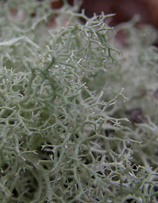
 A couple of lichens. Old Man’s Beard (Usnea strigosa) and, probably, Perforated Ruffle lichen (Parmotrema perforatum). There weren’t many lichens along this trail. It was nice to see these together. Not a plant, but fun to find fruiting.
 I believe this is Spreading Chervil (Chaerophyllum procumbens). At first I thought it was a fern and it took a couple of days before I remembered that Speading Chevil looked like a fern at first glance. I’ve been fooled by this plant before. There were several plants along the trail along the stream but the thickest patch was higher up the hill where the trail entered the cedar woods.
 Eastern Prickly-pear (Opuntia humifusa). These plants look a little sad at the moment. Hopefully, it won’t be long before new growth rejuvenates the plants. These plants were where the trail entered the stone outcrop.
 False Garlic (Nothoscordum bivalve). Just a few plants were blooming among the Bluets along the west margin of the outcrop.
 Oneflower stitchwort or Piedmont Sandwort (Minuartia uniflora). These were just starting to bloom. I saw only a couple of blooms but many plants were in bud.
 Grimmia Dry Rock Moss (Grimmia sp). This moss turns from a rich green when moist to a gray-black color when dry. This photo shows both moist (foreground) and dry moss (background). Large areas of the outcrop were covered with this moss. Hopefully, we’ll see it fruit and be able to identify the species.
In spite of this not being the optimal month for wildflowers at Rock and Shoals Outcrop Natural Area to see wildflowers, we found a wide variety of interesting plants some in bloom and some promising blooms in the future. I’m sure we’ll be walking this trail several times during the year.
Click on an image to view a larger image
Identification resources:
- Will Cook. Trees, Shrubs, and Woody Vines of North Carolina: Painted Buckeye (Aesculus sylvatica)
- Missouri Plants: Spreading Chervil (Chaerophyllum procumbens)
- Southeastern Plants: Eastern Prickly-pear (Opuntia humifusa)
- Native and Naturalized Plants of the Carolinas and Georgia: Eastern Prickly-pear (Opuntia humifusa)
- Southeastern Plants: False Garlic (Nothoscordum bivalve)
- Southeastern Plants: Oneflower stitchwort (Minuartia uniflora)
- Hugh and Carol Nourse. Favorite Wildflower Walks in Georgia. University of Georgia Press, Athens, Georgia
Related posts:
- Rock and Shoals Outcrop Natural Area; Part 1, Blue Trail
- Rock and Shoals Outcrop Natural Area: Plants Along The Stream
The Rock and Shoals Outcrop Natural Area trail is less than one-half mile in length, round trip. The walk can be divided into two sections: the woods along the stream and the walk up the hill to the stone outcrop. We took this walk just to check out the area for future reference. We didn’t expect to see much in the way of plants or flowers on this walk, ‘The Book’ said that there weren’t many flowers in the woods. But the trail along the creek turned out to be a gem for plants, even at this time of year. These are the ones that caught my eye.
 A Cutleaf Fern (Botrychium dissectum) otherwise known as the Dissected Grapefern. Almost the first thing I saw as we started out. A good omen. We saw several of these along the trail.
 Fiddle heads. I don’t know what fern they are but they provided interesting accents with their unusual shapes.
 Wild Ginger or Little Brown Jug (Hexastylis arifolia). I didn’t poke around in the leaves. It’s too early. But these may bloom in late April. The flowers may stay hidden in the leaves and you have to carefully move the leaves aside to see the blooms.
 Pipsissewa or Spotted Wintergreen (Chimaphila maculata). The characteristic leaves are a dead giveaway. I wonder if these will bloom. They have the most exquisite flowers. One of my absolute favorites. Well worth stalking.
 Cankerweed (Prenanthes serpentaria), I believe. They are just starting to develop their characteristic leaf shape. I have a love-hate relationship with Cankerweed. At Fort Yargo State Park, I stalked a big patch of them at one site all year hoping to identify them, and they didn’t bloom well at all. I found a few plants in another area that bloomed beautifully. I wonder if these will bloom.
 A nicely shaped stand of Switchcane or Rivercane (Arundinaria gigantea). These plants are seen in moist gullies and along creeks. It’s a little unusual to see a clump like this.
 This fern has unfurled along the stream bank. It’s probably the same fern as above but I don’t know what it is. I’m not very good at ferns.
 A close up of a leaf of the Downy Rattlesnake Plantain (Goodyera pubescens). This is another plant that’s easy to recognize by its leaf. I only know of one other plant, at Fort Yargo State Park. I haven’t seen it bloom yet but now I have two plants I can stalk in August when it might bloom.
 Mayapple (Podophyllum peltatum) plants. ‘The book’ said there was a colony of Mayapples beside the creek. I’ve never seen them before but recognized them from photographs. I was excited to find them and I’ll be back to photograph the flowers in a month or so.
 What is this? ‘The book’ says that the understory in the woods is dominated by Eastern Hophornbeam (Ostrya virginiana). This was the dominant plant in the understory. So I’ll be back to check these out and hope to see it in flower.
 Cranefly Orchid (Tipularia discolor) plants were betrayed by their leaves. We saw these repeatedly along the trail through the woods. It’ll be interesting to see if these bloom. Of course the leaves will have died back by then. But, given how many plants we saw, it shouldn’t be too difficult to spot the orchids.
More about the plants on the hill in the next post.
Click on an image to view a larger image
Identification resources:
- United States Department of Agriculture Plants Database: Botrychium dissectum (Cutleaf Grapefern)
- Southeastern Plants: Wild Ginger or Little Brown Jug (Hexastylis arifolia)
- Southeastern Plants: Pipsissewa or Spotted Wintergreen (Chimaphila maculata)
- Southeastern Plants: Cankerweed (Prenanthes serpentaria)
- Southeastern Plants: Switchcane or Rivercane (Arundinaria gigantea)
- Southeastern Plants: Downy Rattlesnake Plantain (Goodyera pubescens)
- Southeastern Plants: Mayapple (Podophyllum peltatum)
- Southeastern Plants: Eastern Hophornbeam (Ostrya virginiana)
- Southeastern Plants: Cranefly Orchid (Tipularia discolor)
- Hugh and Carol Nourse. Favorite Wildflower Walks in Georgia. University of Georgia Press, Athens, Georgia
Related post:
- Rock and Shoals Outcrop Natural Area; Part 1, Blue Trail
The Rock and Shoals Outcrop Natural Area must be one of the best kept secrets in plain sight in Georgia.
Although we’re still looking for wildflowers along traveled roads, it’s clear that we need to find access to areas off-road to see wildflowers that occur in different ecological niches. I first ran across Rock and Shoals Outcrop Natural Area listed in Georgia's Wildlife Management & Wildlife Resources Division Areas. Since no map was available, I ‘googled’ Rock and Shoals Outcrop Natural Area in search of an address. There were a couple of links to articles in the Athens (Georgia) Banner Herald’s OnlineAthens that extolled the value of this area but didn’t tell how to get there. Both articles - ‘Two unique 'natural areas' found in Athens' backyard’ and ‘Desert in the woods’ - are well worth reading to get a flavor of the area. This area was listed as an area of interest, and adjacent to Colonels B&B at Angels Oak Farm but still no directions. Discover Life website listed it as a place to see False Garlic (Nothoscordum bivalve).
And then I found it. Favorite Wildflower Walks in Georgia by Hugh and Carol Nourse. This book provides information on 20 walks in Georgia, some in each of four areas: Cumberland Plateau Ridge and Valley, Blue Ridge, Piedmont, and Coastal Plain. The Blue Trail in the Rock and Shoals Outcrop Natural Area near Athens was one of the walks. And… The authors gave directions to the trail. At last!
 The weather alternated between cloudy and sunny, and affected the atmosphere in the woods during our
walk. The woods had an eerie appearance when it was cloudy and cheerful when it was sunny. We didn't see many birds but were serenaded throughout the walk by some woodpeckers that were hammering on trees in search of food.
 The trail head. Indeed, the mailbox did contain copies of the trail map. I suspect that the folks at the Colonels B&B may replenish the supply. If so, thanks! The trail is accessed down a set of steep stairs. There now is a handrail – if somewhat unstable and low – by the stairs but care should be taken when descending them. Once on the trail, the going was generally easy.
Note: The guidebook indicates that the trail is marked with blue tape. There was no tape but the trail is well worn and we had no trouble finding our way.
The trail winds its way beside a small stream in gully that drains into Cedar Creek. There are many points of interest along the trail. The trail is less than one-half mile long round trip, but we spent more than two hours exploring.
 A fallen tree that is covered with moss.
 A tree with a hollow at its base. We saw several similar dark holes at tree bases, under rocks, and along the stream bank. It was cloudy and a little eerie. We started to joke about expecting to see elves in the woods.
 The bank was open here and we could see the course the stream was following.
 The stream bank was steep here. We encountered some squabbling Carolina Chickadees (Poecile carolinensis) and Tufted Titmice (Baeolophus bicolor) in the branches to the left just below the center of the photograph. It’s also clear how much the sunshine brightens the atmosphere in the woods.
 The stream just above the cascade.
 The cascade from ‘below.’ To reach the stone outcrop one has to ford the stream on solid granite rock just above the top of the cascade. There were some patches of dry rock so we could cross without getting our feet wet. If it has rained recently one couldn’t cross without getting one’s feet wet. The trail to the stone outcrop goes straight uphill from the crossing. However, many walkers have worn a trail along the stream bank in order to photograph the cascade. This photo was taken from this side trail.
Note: The stone outcrop is difficult to photograph but I'll share some plant photographs from that area in the next post.
 This photo was taken on the return trip looking across the stream just above the ford.
 Almost back to the trail head. Tree trunks in the sun.
Some of the websites that listed this area gave phone numbers to contact regarding this area. I suspect there is some concern about attracting too many visitors to this area. Parking is at the end of a road through a subdivision and is very limited.
We found many plants of interest along the trail even this early in the season and will be visiting this location many times to try and view others that bloom during the year. More about the plants in the next post.
Click on an image to view a larger image
At last!
The lake level was lowered late last year for some construction. The level was lowered to about six feet at the overflow. Right at the end of the year, the lake started to refill. It’s taken a couple of months to fill again. Three weeks ago, the level was just below 22 feet. After about one-half inch of rain, the level rose to just above 22 feet. The following week, the level had reached just above 23 feet.
And last week we had more than 2 inches of rain. Couldn’t put it off any longer. Back on the lake this morning.
 And the lake level was just under 24 feet. Note that the photo was taken at water level, not looking down on the lake as I’ve had to do for the last few months. The level had been higher. Debris on the bank where I launched indicated that the lake level had risen as much as six inches above the bank. The water is still muddy and there was a lot of debris floating in the water. But still…
 And to prove it. The GPS trace of my route today.
It was great to be out on the water again.
Click on an image to view a larger image
Related posts:
- Fort Yargo State Park: Déjà Vu
- Fort Yargo State Park: Won’t Be Long Now… (Part 2)
 Mary at Neotropical Savannah has also had to wait a while for her Gotcha! moment. When she was working to identify a liana vine with sandpapery leaves, she found references to a tree, the Sandpaper Tree (Curatella americana), in the same family. Although she found saplings of the tree, they didn’t have the distinctive wavy edged leaf morphology described for mature plants. So she’s been lying in wait and actually exclaims, Gotcha!, when she finally found one fruiting this year and was able to complete her photographic collection. Patience pays off!
 Once we’ve taken care of feeding ourselves, we can look to beautifying our surroundings. We’ve all seen those ugly, tall fences or walls that preserve privacy from urban sidewalks. Phytophactor shares a wall where the judicious use of plants of different heights, colors and textures has rendered a simple, yet beautiful sidewalk garden to conceal an ugly wall.
 We’ve all heard of the Tallgrass Prairie that once spread from the Mississippi River to the foothills of the Colorado Rockies even if we haven't seen them. And we're probably somewhat aware of the loss of most of the prairie. Sally at Foothills Fancies brings us some good news. She’s pondering an increase in areas in the foothills of the Colorado Rockies that are covered with Big Bluestem Grass (Andropogon gerardii) and tells us how to differentiate between Big Bluestem and other grasses one encounters in her neck of the woods.