Podophyllum peltatum is called by the common names Mayapple, May-apple, American Mandrake, Devil's Apple, Hog-apple, and Indian Apple. We saw a ‘grove’ of Mayapples on the creek side of the trail at the Rock and Shoals Natural Area on March 19th. I’d never seen Mayapples before so I was looking forward to looking for blooms.
 The plants were just emerging from their Winter hibernation in mid-March.
 Just out of the ground; leaves are folded against the stalk
 Leaves are just starting to unfold
 Leaves are starting to open out
 Leaves are fully opened. These plants are easy to recognize.
 The grove was well-developed in mid-April
 In natural light, we could just spot one or two plants that had bloomed.
 Some artificial light made them easier to see.
 A close view of the bloom in profile. The delicate veins in the petals are visible.
 A close view of the younger of two flowers. Flowers last for only a day or two.
 A close view of a slightly older flower. The ovary is already enlarged indicating that this flower was probably fertilized. We will have to check back to see if the fruit, called a Mayapple apple or an ‘Ozark’ lime, develop.
Podophyllum peltatum (Mayapple) is native to North America and is found in open woods in the eastern United States and Canada.
Click on an image to view a larger image
Distribution Map:
- United States Department of Agriculture Plants Database: Podophyllum peltatum (Mayapple)
- University of North Carolina Herbarium: Podophyllum peltatum
Identification resources:
- Southeastern Flora: Mayapple (Podophyllum peltatum)
- Natural and Naturalized Plants of the Carolinas and Georgia: May-apple, American Mandrake (Podophyllum peltatum)
- Missouri Plants: Mayapple (Podophyllum peltatum)
Related posts:
- 2010: Year Of The Wildflower – Wildflower Index
- Rock and Shoals Outcrop Natural Area; Part 1, Blue Trail
- Rock and Shoals Outcrop Natural Area: Plants Along The Stream
- Rock and Shoals Outcrop Natural Area: Mid-April Wildflowers
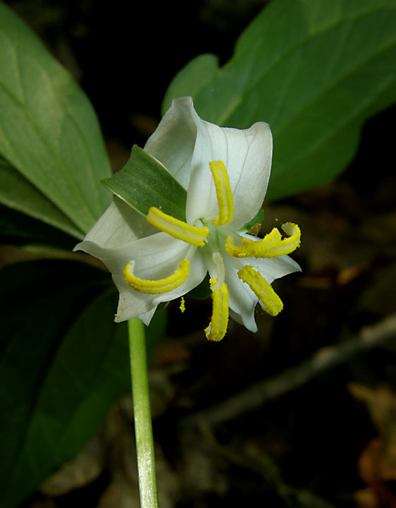
Trillium catesbaei is known by several common names: Catesby's Trillium, Rosy Wake-robin, Bashful Trillium, Rose Trillium, Bashful Wakerobin. We found them by the trail along the creek at Rock and Shoals Outcrop Natural Area in Athens-Clarke County, Georgia, in mid-April. The plants were on the uphill side of the trail not far from a tree with a large hollow at the base of its trunk.
 Catesby’s Trillium flowers hang below the leaves in contrast to most Trillium sp. whose flowers stand above the leaves. This plant was growing in deep shade and was only 6 to 7 inches tall.
 Young flowers are white.
 This plant was growing in a more open area. It was about 12 to 15 inches tall.
 A closer view
 *****
***** Flowers turn pink as they age.
Trillium catesbaei is native to the southeastern United States: North and South Carolina, Georgia, Alabama and southeast Tennessee.
Click on an image to view a larger image
Distribution Map:
- United States Department of Agriculture Plants Database: Trillium catesbaei (Bashful Wakerobin)
- University of North Carolina Herbarium: Trillium catesbaei
Identification resources:
- Southeastern Flora: Bashful Wakerobin (Trillium catesbaei)
- Natural and Naturalized Plants of the Carolinas and Georgia: Catesby's Trillium, Rosy Wake-robin, Bashful Trillium, Rose Trillium (Trillium catesbaei)
Related posts:
- 2010: Year Of The Wildflower – Wildflower Index
- Rock and Shoals Outcrop Natural Area; Part 1, Blue Trail
- Rock and Shoals Outcrop Natural Area: Mid-April Wildflowers
We first explored the Rock and Shoals Natural Area on March 19th. It was clear that the trail held great promise for unusual wildflowers, both along the creek and up on the hill at the stone outcrop. We weren’t sure when many of the wildflowers would bloom so we returned on April 15th to check out the trail.
 It was a cloudy day which gave the woods a slightly eerie feeling. Not an auspicious start to our walk but...
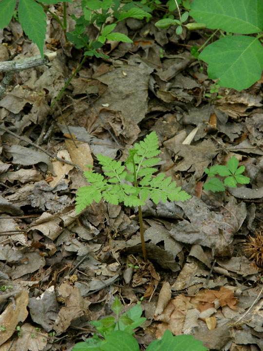
 We found many Rattlesnake Ferns (Botrychium virginianum). This one is just starting to fruit.
 A couple of Wild Ginger (Hexastylis arifolia; Little Brown Jug) plants were also blooming. Unfortunately something had nibbled on the flowers but you can see some nice blooms here.
 The first major find of the day. A Catesby’s Trillium (Trillium catesbaei). We hadn’t seen any hint of these on our previous visit. We knew they were here but we didn't know if we were too early or too late in mid-March. Now we know. Just a taste here; more pictures soon.
 Another major find. Mayapples (Podophyllum peltatum) in bloom. On our previous visit, the plants were just emerging from their winter dormancy. Now a couple were in bloom. More pictures of these soon too.
 Painted Buckeye (Aesculus sylvatica) plants were just beginning to bloom in mid-March. Most had finished blooming but these strikingly colored flowers were on a tree deep in the shade of the woods.
 Hairy Spiderwort (Tradescantia hirsuticaulis). Another surprise. We probably had seen the first sign of these plants in mid-March. I believe we called them ‘grassy things’ then. Now we know what they were. We found plants in various stages of blooming along the trail before we crossed the creek. Then we found them growing abundantely on the hillside by the trail leading up to the stone outcrop.
 A special treat also. We didn’t see the spiders (Harvestmen; Opiliones) when we were photographing the flowers. Is this why these flowers are called spiderworts? No. See the origin for the name spiderwort here. More pictures soon.
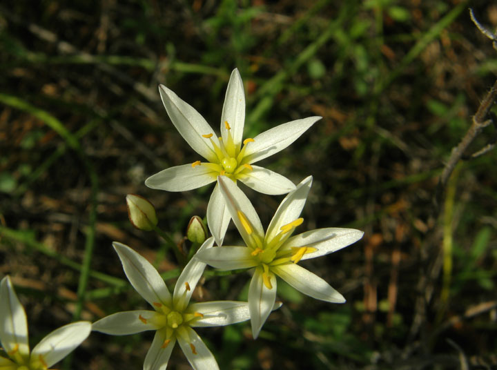
 On the top of the hill and around the stone outcrop, we found False Garlic (Nothoscordum bivalve) plants in full bloom. A treat.
 Oneflower Stitchworts (Minuartia uniflora) were only beginning to bloom in mid-March – literally only one or two blooms. Now they were carpeting the area around the stone outcrop.
 Amur Honeysuckle (Lonicera maackii). At least I think that’s what it is based on photographs of its leaves and flowers. This was a surprise. This plant, unlike its vine cousins, Japanese Honeysuckle (Lonicera japonica) and Trumpet Honeysuckle (Lonicera sempervirens), was a tree about 8 to 10 feet tall. A single tree stands against the cedars on the north side of the stone outcrop.In addition to these plants, we found Yellow Woodsorrel (Oxalis stricta), Field madder (Sherardia arvensis), Low-hop clover (Trifolium campestre), Yellow Sunnybell (Schoenolirion croceum), and Purple Deadnettle (Lamium purpureum)
.
 Occasionally the sun broke through the clouds and gave the woods a totally different feel. Even if the sun hadn’t shone, the wildflower finds this day alone would have brightened our spirits.
Click on an image to view a larger image
Distribution Map:
- United States Department of Agriculture Plants Database: Trillium catesbaei (Bashful Wakerobin)
- University of North Carolina Herbarium: Trillium catesbaei
- United States Department of Agriculture Plants Database: Podophyllum peltatum (Mayapple)
- University of North Carolina Herbarium: Podophyllum peltatum
- United States Department of Agriculture Plants Database: Tradescantia hirsuticaulis (Hairy Spiderwort)
- University of North Carolina Herbarium: Tradescantia hirsuticaulis
- United States Department of Agriculture Plants Database: Aesculus sylvatica (Painted Buckeye)
- University of North Carolina Herbarium: Aesculus sylvatica
- United States Department of Agriculture Plants Database: Lonicera maackii (Amur Honeysuckle)
- University of North Carolina Herbarium: Lonicera maackii
Identification resources:
- Southeastern Flora: Bashful Wakerobin (Trillium catesbaei)
- Natural and Naturalized Plants of the Carolinas and Georgia: Catesby's Trillium, Rosy Wake-robin, Bashful Trillium, Rose Trillium (Trillium catesbaei)
- Southeastern Flora: Mayapple (Podophyllum peltatum)
- Natural and Naturalized Plants of the Carolinas and Georgia: May-apple, American Mandrake (Podophyllum peltatum)
- Southeastern Flora: Hairy Spiderwort (Tradescantia hirsuticaulis)
- Natural and Naturalized Plants of the Carolinas and Georgia: Hairy Spiderwort (Tradescantia hirsuticaulis)
- Southeastern Flora: Painted Buckeye (Aesculus sylvatica)
- Natural and Naturalized Plants of the Carolinas and Georgia: Painted Buckeye (Aesculus sylvatica)
- Missouri Plants: Amur or Bush Honeysuckle (Lonicera maackii).
- Natural and Naturalized Plants of the Carolinas and Georgia: Amur Bush-honeysuckle or Amur Honeysuckle (Lonicera maackii)
Related posts:
- 2010: Year Of The Wildflower – Wildflower Index
- Rock and Shoals Outcrop Natural Area; Part 1, Blue Trail
- Rock and Shoals Outcrop Natural Area: Plants Along The Stream
- Rock and Shoals Outcrop Natural Area: Plants Up The Hill
Continuing from the Rocky Trail – South Lake Trail …
 As we entered the woods, we saw the Fern Trail, marked by a yellow blaze, going off to the south. We’ll have to walk that trail on another day.
 The Arabia Lake Trail circles the lake. We walked on the east side of the lake to meet up with the Forest Trail. Along the trail, where seeps emerged along the bank, we saw more leaves of more trout lilies (Erythronium sp.).
 We were a little amused by this sign warning of thin ice, especially since it was 85 F that day. But in winter, ice may form on the lake but it would be very thin. Hence the danger sign.
 We joined the Forest Trail starts at the northeast ‘corner’ of the lake and walked along a relatively level trail for a short while.
 The trail then climbed back up to the ridge, skirting the northern end of the stone outcrop, to return to the parking lot.
 In a shady grove near the end of the Forest Trail, we spotted a small grove with about a dozen Pink Lady's Slipper (Cypripedium acaule) orchids.
 On April 9th, the orchids were just beginning to open.
 The Forest Trail crossed the PATH trail to return to the parking lot. We chose to walk back to the parking lot on the paved PATH trail. PATH is a foundation that builds trails for walkers, runners, cyclists, and skaters. The Arabia Mountain path currently runs from Lithonia to Alexander’s Lake, just east of Panola Mountain State Park.
Click on an image to view a larger image
Related information:
PATH Foundation: Arabia Mountain Trail [Online trail map]
Related posts:
- Davidson-Arabia Mountain Nature Preserve: RR Trail - Frog Pond Trail
- Davidson-Arabia Mountain Nature Preserve: Frog Pond Trail
- Davidson-Arabia Mountain Nature Preserve: Rocky Trail – South Lake Trail
- Davidson-Arabia Mountain Nature Preserve: Bradley Mountain Trail (Part 1)
Continuing from the Frog Pond Trail…
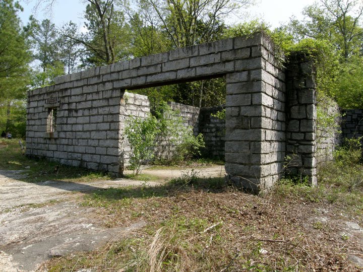
From the quarry buildings at the end of the Frog Pond Trail, the South Lake Trail travels west over the stone outcrop to the woods and Arabia Lake. The South Lake Trail is marked with stone cairns. We left the trail on the Rocky Trail to find the Fern Trail and follow it to Arabia Lake.
 Where the Rocky Trail left the South Lake Trail, the bank was covered with a blanket of Oneflower Stitchwort (Minuartia uniflora) in the foreground, Woolly Ragwort (Packera tomentosa) in the background, and False Garlic (Nothoscordum bivalve) to the right.
 Close up of the False Garlic flowers.
 The bank at the edge of the woods to the east of the Rocky Trail, a trail that is not marked with stone cairns. The bank was about 4 feet high. Organic matter from the woods has accumulated on the bank which no longer has the harsh scars from quarrying.
 The outcrop to the south side of the trail also shows signs of quarrying that have not softened with time. Some Loblolly pines (Pinus taeda) have established on the outcrop.
 As we approached the woods at the end of the Rocky Trail, we crossed a seep. Elf Orpine (Diamorpha smallii) blankets the thin soil on the outcrop in the foreground. Woolly Ragwort grows in the thicker soil along the seep.
 As we were looking for the Fern Trail, we found the forest floor at the edge of the stone outcrop covered with fruiting Polytrichum commune moss and trout lilies (Erythronium sp.). We also found this small patch of Pixie Cup lichen (Cladonia carneola).
We couldn’t find the Fern Trail. We worked our way along the edge of the stone outcrop in the hope that we would spot the trail.
 We found another area with a carpet of Elf Orpine in the foreground and Woolly Ragwort in the background.
At the southwest end of the stone outcrop we gave up our search for the Fern Trail and made our way back northeast around a patch of trees to the South Lake Trail. As we walked across the outcrop, a Kildeer (Charadrius vociferus) dashed from an area of Elf Orpine and began its ‘broken wing’ routine to distract us from its nest. Unfortunately, we didn’t get any photographs as she moved around so quickly. We looked around for the nest but the Elf Orpine carpet was so large, it would have taken a long time to search thoroughly.
 We crossed this seep just before we reached the South Lake Trail
 The last section of the South Lake Trail to the arch at the edge of the woods was fairly bare, with just a few scant patches of Elf Orpine.
From here we ventured entered the woods to reach Arabia Lake after a short walk. Then to the Arabia Lake and Forest Trails…
Click on an image to view a larger image
Related posts:
- Davidson-Arabia Mountain Nature Preserve: RR Trail - Frog Pond Trail
- Davidson-Arabia Mountain Nature Preserve: Frog Pond Trail
- Davidson-Arabia Mountain Nature Preserve: Bradley Mountain Trail (Part 1)
 The plants were just emerging from their Winter hibernation in mid-March.
 Just out of the ground; leaves are folded against the stalk
 Leaves are just starting to unfold
 Leaves are starting to open out
 Leaves are fully opened. These plants are easy to recognize.
 The grove was well-developed in mid-April
 In natural light, we could just spot one or two plants that had bloomed.
 Some artificial light made them easier to see.
 A close view of the bloom in profile. The delicate veins in the petals are visible.
 A close view of the younger of two flowers. Flowers last for only a day or two.
 A close view of a slightly older flower. The ovary is already enlarged indicating that this flower was probably fertilized. We will have to check back to see if the fruit, called a Mayapple apple or an ‘Ozark’ lime, develop.