two swamps on Enoch John Road,
Fishing Creek Wildlife Management Area (WMA) and the Broad River WMA; we return
to the beginning of the route via Pistol Creek.
We left the swamps on Enoch John
Road and drove down Jones Chapel Road to Fishing Creek Wildlife Management Area
(WMA).
On the way, we sighted a Red-spotted
Purple (Limenitis arthemis) butterfly, and
Yellow-sided Skimmer (Libellula flavida).
The boundary of the WMA had
undergone maintenance recently. Vegetation along the boundary had been cleared
and the trees marking the boundary were visible. Trees are marked with one,
two, or three orange bands. A tree with one band indicates the boundary and a
tree with three bands marks a ‘corner’ where the boundary changes direction; I
forget what the two bands means.
A new sign had been installed at the entrance to the WMA.
This WMA is intended primarily for hunting and camping is allowed only near the
entrance.
The roads wind through pinewoods. It was along this road that we found a Luna Moth.
We have visited this WMA because it is a good place to see
Clasping Milkweed (Asclepias amplexicaulis) plants near a couple of the roads
within the WMA.
We left the WMA and
drove north on Ohara Standards Road, not expecting to see much in the way of
wildflowers. However, we found more…
Common Blue-eyed Grass (Sisyrinchium angustifolium) plants in bloom.
The real ‘find’ for the day were the Narrowleaf Evening Primrose (Oenothera fruticosa) plants in bloom along Ohara Standard Road before we reached Morris Creek. (I’ll post these photographs separately.
I found a lone Violet Woodsorrel (Oxalis violacea) in bloom.
From Ohara Standard Road, we drove north on GA-44 and GA-79, and then turned left on Delhi Road to reach Bolton Road. We have found a lot of Clasping Milkweed plants along Bolton Road, particularly north of Pistol Creek. We’ve found Monarch Butterfly caterpillars on milkweed plants at the north end of this road. From here, we turned right onto Broad Road and, then almost immediately, turned onto Anthony Shoals road into the Broad River WMA.
We drive both of the roads – Anthony Shoals and C Johnson Road – in this WMA. Originally, we drove these roads in search of Clasping Milkweed plants. Over the years, we’ve encountered Black Rat (Elaphe [Pantherophis] obsoleta) near C Johnson Road but we were out of luck on this trip.
We found a patch of…
Needle-tipped Blue-eyed Grass (Sisyrinchium mucronatum) blooming on Anthony Shoals Road.
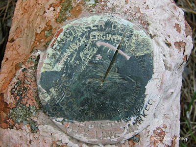
Interestingly, there are two WMA border corners near Anthony Shoals Road. The corners are marked with four trees, each with three orange bands. The marker for the boundary corner is in the ‘center’ of the area surrounded by the trees.
The marker is usually attached to the top of a concrete block.
The marker. It reads
U. S. ENGINEERING DEPARTMENT
SAVANNAH ENGINEERING DISTRICT
$250 OR IMPRISONMENT
FOR DISTURBING THIS MARKER
PROPERTY LINE MARKER
In the clear-cut near
the end of Anthony Shoals Road.


No comments:
Post a Comment