Not only had I forgotten about the Hazel Alders blooming, I’d also forgotten that other trees would be starting to bloom too.
 The Red Maples (Acer rubrum) were setting buds. The trees are showing the red cast they get as they set buds and start to bloom.
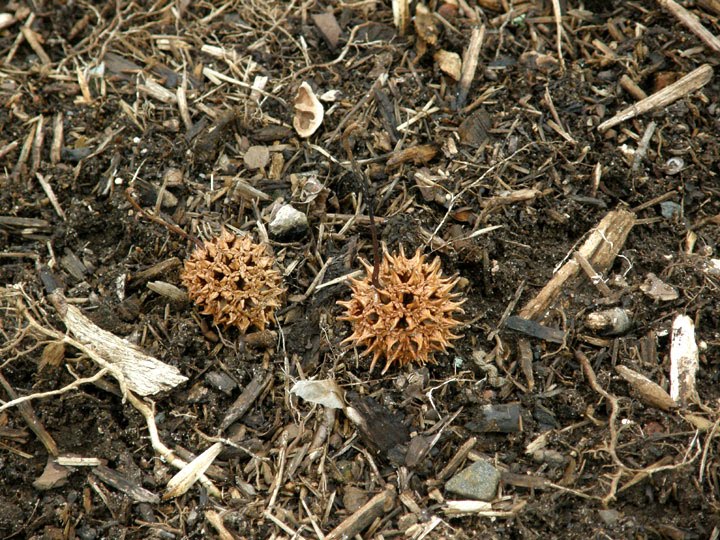
 This morning, several trees are blooming. These are trees that I photographed last year will set seed. Sweetgums (Liquidambar styraciflua) and Elliott's Blueberry (Vaccinium elliottii) are also setting buds.
 Some interesting drift wood. This is large; about 3 feet in length.
 This morning, with more drainage into the lake and some rain during the week, the water has risen another 2 to 3 inches. Might not be able to walk the full length of this beach in another week.
 One of two large ‘inlets,’ created by erosion from above, that are the reason that the trail doesn’t follow the shoreline along this beach. The trail has to climb up to the ridge and down to the shore again to avoid these inlets.
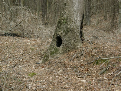 Off to the right of the inlet, this tree has an inviting hole that I had assumed would provide shelter for small creatures. Or so I thought. When I took a closer look at it this morning, there are three openings into this hole. It wouldn’t provide much shelter.
 Some more interesting driftwood. This is a tree trunk that has ‘delaminated’ over time. It looks like the earlywood with its wider elements may have decomposed and the denser latewood has survived as layers of wood.
 Remains of a feast. The shells of the small freshwater bivalves are all that remain of a meal had by some of the furry denizens of the park. It’s not unusual to find piles of shells along the shore.
 A spider hidden in plain sight on an alder catkin. I was steadying the catkin to photograph it when I realized I wasn’t alone. The spider didn’t move during the several minutes I was photographing.
 The University of Georgia Dock to the Point
 The Boat Launch and Dock
A couple of photographs, taken on November 7th 2010, of the shoreline near the boat launch at the beginning of my walk.
 The shoreline last Monday, February 21 2011.
Fishermen are back on the lake. There were four or five boats out last Monday and again this morning. I won’t have an excuse not to go out soon. I’d rather see another foot of water before I do. I’ve seen the obstacles that would still be just under the surface. I’d rather not bottom out on them.
Click on an image to view a larger image
Related posts:
- Fort Yargo State Park: Won’t Be Long Now… (Part 2)
- Fort Yargo State Park: Won’t Be Long Now… (Part 1)
- Fort Yargo State Park: Déjà Vu
- Fort Yargo State Park: A Cold, Sunny Day
- Fort Yargo State Park: Shades Of Brown And Green. Part 1
- Fort Yargo State Park: Shades Of Brown And Green. Part 2
- Snow: Fort Yargo State Park
- Boat Launch To The Picnic Area: ‘Low Tide'
The lake level was lowered in late October/early November, 2010. so that the braces on the supports under the pedestrian bridge at Section B could be replaced. It was a little disappointing but did allow for access to the shoreline again.
 Maps of the park have been placed in notice boards at various places in the park. This map is at the boat launch at Section B.
 Trail: Park Map
 Trail: Satellite View (Google maps)
The trails that I followed – on the park map and on a Google satellite image. I followed the hiking trail to point A. From point A, I a followed a trail not marked on the park map to point B where I joined the Monster Mile Bypass and followed this trail down to the dam. I followed the hiking trail back along the lake to point C where I left the trail and walked, almost back to the starting point, along the shoreline.
 The water level at the pedestrian bridge on February 20, 2011. Compare this with…
 The lake level at approximately the same place on December 19th, 2010.
 Hazel Alder (Alnus serrulata) catkins. I’d forgotten that the alders would be flowering now. These were at the south end of the pedestrian bridge.
 Looking along the trail just past the pedestrian bridge. The sunlight on this morning was magical, particularly after a number of cloudy days.
 The trail climbs the hill to a plateau. The trail surface, which is clay, looks as if it has been polished. The trail leads away from the lake to a right-of-way and then…
 The trail enters the woods after crossing and open area. This trail winds its way back down to the lake. Again the sunlight in the woods was striking.
 Looking back along the trail just before it reaches the lake shore again.
 At the beginning of the steep climb - from 915 ft to 945 ft above sea level (a.s.l.) – to Point A on the trail. It seems much steeper.
 Looking northeast along the trail that leads back down to the lakeshore. The trail drops into an open basin before it begins the serious descent to the lake.
The trail I followed to point B made an initial climb to 962 ft a.s.l., descended a little to the Tulip Poplar (Liriodendron tulipifera) tree and then curved and climbed to 986 ft a.s.l. to join the Monster Mile Bypass.
 Looking down the Monster Mile Bypass trail that leads to the dam.
 I almost missed this fern. It’s a grape fern (Botrychium sp.). I know where two grow deeper in the woods and had checked to see if they had emerged yet. Since they hadn’t, I wasn’t expecting to see one in this area.
 A closer view of the grape fern. It’s in a well-lighted location. I will be surprised if this fern sporulates.
Next stop, the dam...
Click on an image to view a larger image
Related posts:
- Fort Yargo State Park: Déjà Vu
- Fort Yargo State Park: A Cold, Sunny Day
- Fort Yargo State Park: Shades Of Brown And Green. Part 1
- Fort Yargo State Park: Shades Of Brown And Green. Part 2
- Snow: Fort Yargo State Park
- Boat Launch To The Picnic Area: ‘Low Tide’
 The Red Maples (Acer rubrum) were setting buds. The trees are showing the red cast they get as they set buds and start to bloom.
 This morning, several trees are blooming. These are trees that I photographed last year will set seed. Sweetgums (Liquidambar styraciflua) and Elliott's Blueberry (Vaccinium elliottii) are also setting buds.
 Some interesting drift wood. This is large; about 3 feet in length.
  This morning, with more drainage into the lake and some rain during the week, the water has risen another 2 to 3 inches. Might not be able to walk the full length of this beach in another week.
 One of two large ‘inlets,’ created by erosion from above, that are the reason that the trail doesn’t follow the shoreline along this beach. The trail has to climb up to the ridge and down to the shore again to avoid these inlets.
  Off to the right of the inlet, this tree has an inviting hole that I had assumed would provide shelter for small creatures. Or so I thought. When I took a closer look at it this morning, there are three openings into this hole. It wouldn’t provide much shelter.
 Some more interesting driftwood. This is a tree trunk that has ‘delaminated’ over time. It looks like the earlywood with its wider elements may have decomposed and the denser latewood has survived as layers of wood.
  Remains of a feast. The shells of the small freshwater bivalves are all that remain of a meal had by some of the furry denizens of the park. It’s not unusual to find piles of shells along the shore.
 A spider hidden in plain sight on an alder catkin. I was steadying the catkin to photograph it when I realized I wasn’t alone. The spider didn’t move during the several minutes I was photographing.
 The University of Georgia Dock to the Point
 The Boat Launch and Dock
 The shoreline last Monday, February 21 2011.